IMAGES TAKEN NEAR TO
Lake Lane, BRIDPORT, DT6 4JY
Introduction
This page details the photographs taken nearby to Lake Lane, DT6 4JY by members of the Geograph project.
The Geograph project started in 2005 with the aim of publishing, organising and preserving representative images for every square kilometre of Great Britain, Ireland and the Isle of Man.

There are currently over 7.5m images from over14,400 individuals and you can help contribute to the project by visiting https://www.geograph.org.uk
Image Map
Images are licensed for reuse under creativecommons.org/licenses/by-sa/2.0
Notes
- Clicking on the map will re-center to the selected point.
- The higher the marker number, the further away the image location is from the centre of the postcode.
Image Listing (128 Images Found)
Images are licensed for reuse under creativecommons.org/licenses/by-sa/2.0
Image
Details
Distance
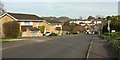
1
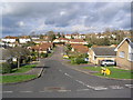
Lake Lane, Westown, Bridport
Modern housing in Lake Lane, Bridport. This is in an area marked on local maps as Westown, but I have never heard the area referred to by this name.
Image: © Stephen Williams
Taken: 25 Feb 2007
0.02 miles
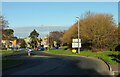
2
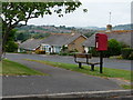
Bothenhampton: postbox № DT6 58, Valley Road
This postbox stands on a quite stiff hill on this estate of bungalows. From the seat alongside there are views across the town of Bridport, which we can just glimpse from this angle. The postbox is emptied at 4pm on weekdays and at noon on Saturdays.
Image: © Chris Downer
Taken: 13 Jun 2009
0.08 miles
3
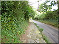
Bothenhampton, pavement
Raised stone rubble pavement on Hollow Way - from Sea Road to Bothenhampton village.
Image: © Mike Faherty
Taken: 22 Sep 2013
0.10 miles
4
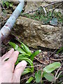
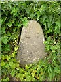
Bench Mark on The Old Barn Westown Bothenhampton
This cut benchmark is hidden in the undergrowth just above soil level on the wall of the Old barn Facing the main road through Bothenhampton. The horizontal line of the mark is missing as this stone or the stone above it may have been moved. For a wider view of location see Image
Image: © Nigel Mykura
Taken: 18 Feb 2021
0.10 miles
5
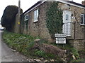
The Old Barn Westown Bothenhampton
This converted barn is on the corner of Westown and Hollow Way and about 50 m west of the junction with Crock Lane. Approximately 1m east of the corner of the building there is a cut benchmark on a stone at ground level. This can be seen in Image
Image: © Nigel Mykura
Taken: 18 Feb 2021
0.10 miles
6
Chestnut Road, Bridport
The road shown at the rear of Image], passing the start of footpath W5 18 on the right as it drops to a small side valley of the Brit.
Image: © Derek Harper
Taken: 1 Nov 2017
0.10 miles
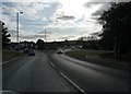
7
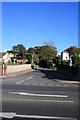
Crown roundabout, Bridport
The eastern side of the roundabout, with the A35 bypass heading northwards, and Sidney Gale House, a care home, on the left. In the foreground, the B3157 arrives at the junction.
Image: © Derek Harper
Taken: 6 Dec 2022
0.11 miles
9
Hollow Way, Bothenhampton
View from the west side of the A35 from the pavement above Flood Lane, looking ESE to Hollow Way and Bothenhampton. Hollow way was the continuation of Flood Lane passing under what is now the A35, and was once railway line to West Bay.
Image: © John Stephen
Taken: 14 Oct 2012
0.12 miles
10
Old Boundary Marker by Hollow Way, Bridport
Parish Boundary Marker by the UC road, in parish of Bridport (West Dorset District), Hollow Way, opposite junction with Lansdowne Road, on embankment.
Inscription reads:-
L B
Surveyed
Milestone Society National ID: DO_BRID02pb
Image: © Milestone Society
Taken: Unknown
0.12 miles