IMAGES TAKEN NEAR TO
Priory Gardens, BRIDPORT, DT6 3FP
Introduction
This page details the photographs taken nearby to Priory Gardens, DT6 3FP by members of the Geograph project.
The Geograph project started in 2005 with the aim of publishing, organising and preserving representative images for every square kilometre of Great Britain, Ireland and the Isle of Man.

There are currently over 7.5m images from over14,400 individuals and you can help contribute to the project by visiting https://www.geograph.org.uk
Image Map
Images are licensed for reuse under creativecommons.org/licenses/by-sa/2.0
Notes
- Clicking on the map will re-center to the selected point.
- The higher the marker number, the further away the image location is from the centre of the postcode.
Image Listing (666 Images Found)
Images are licensed for reuse under creativecommons.org/licenses/by-sa/2.0
Image
Details
Distance
1
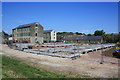
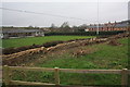
Priory Gardens housing development, Bridport.
Development of land behind Priory Mill and between the Evangelical Chapel on Priory Lane (the long low building) and the River Brit flood defence banking. The big old mill buildings have been converted to flats. See also Image
Image: © John Stephen
Taken: 13 Jun 2010
0.02 miles
2
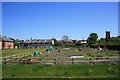
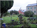
Priory Lane allotments
New allotments between Priory Lane and the Brit being cultivated for the first season. View from banks of River Brit.
Image: © John Stephen
Taken: 22 May 2012
0.02 miles
3
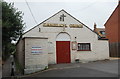
Bridport evangelical church
Formerly part of the adjacent mill and Grade-II listed (ref. 1216438): https://www.britishlistedbuildings.co.uk/101216438-bridport-chapel-bridport#.WhyCNSZLGAg .
Image: © Bill Harrison
Taken: 9 Jul 2016
0.02 miles
4
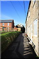
Priory Lane, Bridport
Looking North towards town with newly finished Priory Gardens development on left and Evangelical Chapel centre.
Image: © John Stephen
Taken: 28 Oct 2011
0.03 miles
5
Palmer's Allotments
Accessed from the bottom of Gundry Lane. The old Priory Mills three storey building is now housing association flats. It was a Youth Hostel in the 70s/80s.
Image: © John Stephen
Taken: 16 Sep 2017
0.03 miles
6
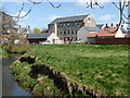
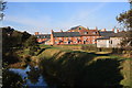
River Brit and Priory Mills, Bridport
Built in the 1830s for Stephen Whetham & Sons, manufacturers of lines, twine and canvas. It was a steam powered mill with an internal engine house and has now been converted to dwellings.
Image: © Chris Allen
Taken: 31 Mar 2015
0.03 miles
7
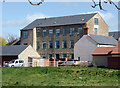
Priory Mills, Bridport
Built in the 1830s for Stephen Whetham & Sons, manufacturers of lines, twine and canvas. It was a steam powered mill with an internal engine house and has now been converted to dwellings.
Image: © Chris Allen
Taken: 31 Mar 2015
0.04 miles
8
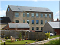
Priory Mills from Gundry Lane, Bridport
Built in the 1830s for Stephen Whetham & Sons, manufacturers of lines, twine and canvas. It was a steam powered mill with an internal engine house and has now been converted to dwellings.
Image: © Chris Allen
Taken: 31 Mar 2015
0.04 miles
9
Bridport Bowling Club
View of the Bowling Club green from the lower corner of the Community Orchard. The hedges running diagonally across the picture delineate Priory Lane. They have been rather severely cut back as they were about 8 feet high but at least they have been laid. The boundary hedge on the far side of the green gives the original height. See also Image The houses on the right behind the bowling green boundary hedge are the newly built Priory Gardens.
Image: © John Stephen
Taken: 8 Jan 2013
0.04 miles
10
River Brit and new Priory Gardens housing
River Brit view from the St Mary's playing field bridge. Priory Gardens housing development finished Nov 2011. Large building behind is old Priory Mills, converted to flats, and left of centre St Michael's Trading Estate tower. Extreme right are the Bowling Club buildings.See also Image
Image: © John Stephen
Taken: 28 Oct 2011
0.04 miles