IMAGES TAKEN NEAR TO
Kings Mill Lane, STURMINSTER NEWTON, DT10 2HH
Introduction
This page details the photographs taken nearby to Kings Mill Lane, DT10 2HH by members of the Geograph project.
The Geograph project started in 2005 with the aim of publishing, organising and preserving representative images for every square kilometre of Great Britain, Ireland and the Isle of Man.

There are currently over 7.5m images from over14,400 individuals and you can help contribute to the project by visiting https://www.geograph.org.uk
Image Map
Images are licensed for reuse under creativecommons.org/licenses/by-sa/2.0
Notes
- Clicking on the map will re-center to the selected point.
- The higher the marker number, the further away the image location is from the centre of the postcode.
Image Listing (10 Images Found)
Images are licensed for reuse under creativecommons.org/licenses/by-sa/2.0
Image
Details
Distance
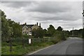
1
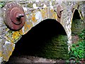
Kings Mill Bridge
The bridge runs east west across the Stour and on the western side the approach road is elevated as it crosses low lying meadows. These are the minor arches that pierce the structure well to the west of the main arches. In times of flood they would allow excess water to flow through. When these shots were taken they were completely dry. The bridge was built in 1823. The structure has been extensively reinforced with tie-bars running through from one side to the other.
Image: © Nigel Mykura
Taken: 18 Oct 2009
0.07 miles
2
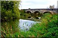
Kingsmill Bridge
Crossing the Stour very close to Kingsmill this bridge was designed by George Allen Underwood (1792-1829) the surveyor for the counties of Somerset (from 1818) and Dorset (from 1821).
Image: © Nigel Mykura
Taken: 18 Oct 2009
0.12 miles
3
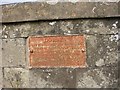
Old Bridge Marker on King's Mill Bridge, Stalbridge parish
Bridge Marker by the UC road, in parish of Stalbridge (North Dorset District), King's Mill Road, King's Mill Bridge.
Inscription reads:-
DORSET
ANY PERSON WILFULLY INJURING
ANY PART OF THIS COUNTY BRIDGE
WILL BE GUILTY OF FELONY AND
UPON CONVICTION LIABLE TO BE
TRANSPORTED FOR LIFE
BY THE COURT
7&8 GEO 4 C30 S13 T FOOKS
King's Mill Bridge is Grade II listed.
List Entry Number: 1171987 https://historicengland.org.uk/listing/the-list/list-entry/1171987
Surveyed
Milestone Society National ID: DO_TRASTAbr
Image: © Milestone Society
Taken: Unknown
0.12 miles
4
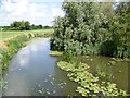
River Stour near Marnhull
Looking upstream from Kings Mill Bridge. The river at this point is covered with yellow water lilies.
Image: © Maigheach-gheal
Taken: 15 Jun 2009
0.13 miles
6
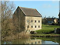
King's Mill, Nr. Marnhull
A fine early C19th mill on the river Stour south of Marnhull.
Image: © Brett Sutherland
Taken: 14 Mar 2007
0.15 miles
7
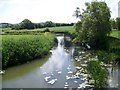
River Stour near Marnhull
Looking downstream from Kings Mill Bridge.
Image: © Maigheach-gheal
Taken: 15 Jun 2009
0.16 miles
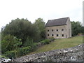
8

Kings Mill
Kings Mill stands beside the River Stour. The mill was built circa 1830 of coursed rubble. There are remains of a wooden water wheel.
Image: © Maigheach-gheal
Taken: 15 Jun 2009
0.16 miles
9

Kings Mill Marnhull
The present building on the River Stour was built in 1829 but there has been a mill on the site for much longer. It is close to a fine stone bridge across the river built in 1823.
Image: © Nigel Mykura
Taken: 28 Sep 2009
0.16 miles
10
King's Mill, near to Marnhull
Built in 1830. See https://britishlistedbuildings.co.uk/101110407-kings-mill-marnhull#.X0JC48hKg2w for entry in British Listed Buildings.
Image: © Bikeboy
Taken: 10 Aug 2020
0.18 miles