IMAGES TAKEN NEAR TO
Shaws Lane, HAWES, DL8 3QB
Introduction
This page details the photographs taken nearby to Shaws Lane, DL8 3QB by members of the Geograph project.
The Geograph project started in 2005 with the aim of publishing, organising and preserving representative images for every square kilometre of Great Britain, Ireland and the Isle of Man.

There are currently over 7.5m images from over14,400 individuals and you can help contribute to the project by visiting https://www.geograph.org.uk
Image Map
Images are licensed for reuse under creativecommons.org/licenses/by-sa/2.0
Notes
- Clicking on the map will re-center to the selected point.
- The higher the marker number, the further away the image location is from the centre of the postcode.
Image Listing (36 Images Found)
Images are licensed for reuse under creativecommons.org/licenses/by-sa/2.0
Image
Details
Distance

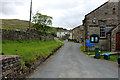
3
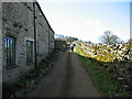
Greystones Cottage
A grade 2 listed cottage at the south end of the village. This property stands at the end of the track up to Burtersett High Pasture and Wether Fell.
Image: © brian alderman
Taken: 3 Feb 2009
0.06 miles
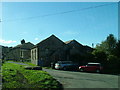
4
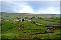
Burtersett from the bridleway to Drumaldrace
Burtersett has limited parking for visitors, but forms the starting point for walks on the south side of Wensleydale, such as the ascent of Drumaldrace or Yorburgh (signposted 'Wether Fell'). Whilst the tops on the south of the dale are often small plateaux more or less surrounded by small crags, the view across the dale shows that the general dip of the strata to the northeast has carried these beds to a position lower on the opposite hillsides, leaving linear scars, but more rounded (and often boggy) hilltops.
Image: © Andy Waddington
Taken: 1 Dec 2020
0.07 miles
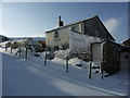
6
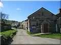
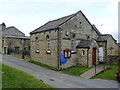
Burtersett Institute
An 1895 OS Map has this building as a Congregational Chapel and School. The 1912 and 1914 maps only mention this building as a Congregational Church which implies the school, may have moved to new premises.
Image: © Les Hull
Taken: 12 Apr 2009
0.11 miles
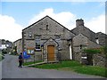
10
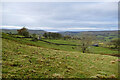
Fields above Shaws Lane
Shaws Lane, walled both sides, runs along behind the pile of film-wrapped bales towards the small patch of woodland conveying a public footpath towards Gayle. Beyond the trees, Hawes is the major community towards the top of Wensleydale, which continues westwards to the dip in the horizon. The branch valley to the right of centre is Cotterdale and to its right again, the ridge (directly behind the foreground Ash tree) is the popular ascent to Great Shunner Fell.
Image: © Andy Waddington
Taken: 1 Dec 2020
0.13 miles