IMAGES TAKEN NEAR TO
Stanhope, BISHOP AUCKLAND, DL13 2PF
Introduction
This page details the photographs taken nearby to DL13 2PF by members of the Geograph project.
The Geograph project started in 2005 with the aim of publishing, organising and preserving representative images for every square kilometre of Great Britain, Ireland and the Isle of Man.

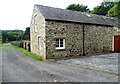
There are currently over 7.5m images from over14,400 individuals and you can help contribute to the project by visiting https://www.geograph.org.uk
Image Map (Loading...)


Getting Data...Please wait
Leaflet Map data © OpenStreetMap
Images are licensed for reuse under creativecommons.org/licenses/by-sa/2.0
Notes
- Clicking on the map will re-center to the selected point.
- The higher the marker number, the further away the image location is from the centre of the postcode.
Image Listing (114 Images Found)
Images are licensed for reuse under creativecommons.org/licenses/by-sa/2.0
Image
Details
Distance
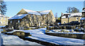
1
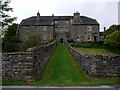
Stanhope Old Hall
A 17th-century fortified manor house, supposedly haunted. Previously run as a Hotel and Restaurant, it is now a private house.
For sale in 2012, at a Guide Price of £895,000, it is described as follows:
"Stanhope Old Hall is a stunning Grade II* listed medieval manor house with origins reputedly dating back to 1139. The beautiful and generous accommodation spans four floors and exudes character with mullioned windows, flagstone floors, heavily beamed ceilings and impressive inglenook fireplaces. The first resident of dwelling on the site was William De Monte in the mid 12th Century with some remodelling and additions taking place in the Elizabethan /Jacobean periods.
It was also the ancient family house of the Fetherstonhaugh’s and was a hunting lodge for the Bishops of Durham. More recently it was operated as a hotel, although it is presently utilised as a private family home.
Stanhope Old Hall presently offers five reception rooms and 10 bedrooms many of which have en suite facilities."
No mention is made of paranormal appearances.
Image: © Andrew Curtis
Taken: 4 May 2009
0.01 miles
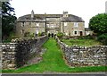
2
Stanhope Hall
Old mansion on the west side of Stanhope town. It dates from the 16th and 17th centuries with later alterations. The house incorporates elements from medieval times.
Image: © Robert Graham
Taken: 13 Aug 2024
0.01 miles
3
Front view of Stanhope Hall
Imposing old manor house from the Tudor period, in the 16th century. Has 17th century sections also and later alterations. It incorporates earlier medieval elements too. Now divided into several private dwellings and a guest house.
Image: © Robert Graham
Taken: 13 Aug 2024
0.01 miles
4
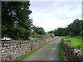
Lane in front of Stanhope Old Hall
The Hall can just be seen in the trees on the left. The lane here runs on up the valley past Crawleyside and on to the moors, as a footpath.
Image: © Robert Graham
Taken: 13 Aug 2024
0.02 miles
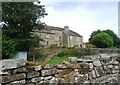
5
Mill outbuildings at Stanhope Hall
These former outbuildings were probably a smithy and stables and date to the early 19th century. Now converted to residential.
Image: © Robert Graham
Taken: 13 Aug 2024
0.03 miles
6
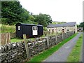
Shepherds hut at Stanhope Hall
In the garden of Stanhope Hall Mill. The mill outbuildings are in the background and date from the early 19th century. They were originally a smithy and stables.
Image: © Robert Graham
Taken: 13 Aug 2024
0.03 miles
7
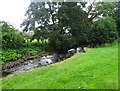
Stanhope Burn near the Hall
This rocky burn flows down from the moors on Stanhope Common and into the River Wear a short way from here. It originally powered Stanhope Hall Mill just upstream from here.
Image: © Robert Graham
Taken: 13 Aug 2024
0.03 miles
8
Properties at Allerton Court, Stanhope
Allerton Court is at the western end of Stanhope on the west side of the Stanhope Burn.
Image: © Trevor Littlewood
Taken: 16 Jan 2023
0.04 miles
9
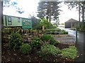
Greenfoot Holiday Home Park, Stanhope
One of a large number of caravan sites in Weardale.
Image: © Oliver Dixon
Taken: 2 Aug 2008
0.04 miles
10

Stanhope Burn beside the Mill
Stanhope Hall Mill is off to the left. The burn would have driven a mill wheel originally.
Image: © Robert Graham
Taken: 13 Aug 2024
0.04 miles