IMAGES TAKEN NEAR TO
Stanhope, BISHOP AUCKLAND, DL13 2EU
Introduction
This page details the photographs taken nearby to DL13 2EU by members of the Geograph project.
The Geograph project started in 2005 with the aim of publishing, organising and preserving representative images for every square kilometre of Great Britain, Ireland and the Isle of Man.

There are currently over 7.5m images from over14,400 individuals and you can help contribute to the project by visiting https://www.geograph.org.uk
Image Map
Images are licensed for reuse under creativecommons.org/licenses/by-sa/2.0
Notes
- Clicking on the map will re-center to the selected point.
- The higher the marker number, the further away the image location is from the centre of the postcode.
Image Listing (10 Images Found)
Images are licensed for reuse under creativecommons.org/licenses/by-sa/2.0
Image
Details
Distance
2
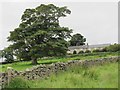
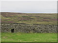
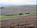
Farmhouse at Steward Shield Meadow
Steward Shield Meadow is a farm on the southern side of Horseshoe Hill, its enclosed land is bounded on three sides by moorland and to the south by the Stanhope Burn. It will also have grazing land on the surrounding moorland.
Image: © Trevor Littlewood
Taken: 19 Jul 2018
0.01 miles
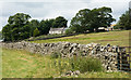
3
Steward Shield Meadow
Farmland in the valley of Stanhope Burn, totally surrounded by moorland.
Image: © Oliver Dixon
Taken: 28 Oct 2008
0.02 miles
4
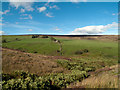
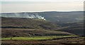
Green oasis
Around Steward Shield Meadow, viewed from Weather Hill
Image: © Kevin Waterhouse
Taken: 19 Apr 2023
0.02 miles
6
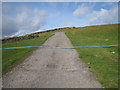
Access track to Steward Shield Meadow
This photograph shows a view of the access track to the farm at Steward Shield Meadow (just behind the photographer). The track climbs steeply up to meet the minor road at Meadows Edge (ahead). The picture was taken looking in a north-westerly direction towards Dead Friar's Stone.
Image: © Philip Barker
Taken: 17 Oct 2010
0.09 miles
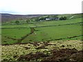
7
Farm at Steward Shield Meadow
Steward Shield Meadow is an isolated farm with its fields surrounded by moorland on the north side of Stanhope Burn. The view here is from the slope above the south side of Stanhope Burn and across the bracken-lined groove of North Thatch Burn.
Image: © Trevor Littlewood
Taken: 8 Sep 2011
0.12 miles
8
Steward Shield Meadow
Photo taken from near the Image
Image: © Mike Quinn
Taken: 17 Aug 2011
0.18 miles
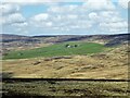
10
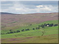
Heather slope descending towards fields
The fields surround the farm at Steward Shield Meadow; they in turn are surrounded by heather moorland. The image was recorded from the route of a high level railway close to the access road for the farm.
Image: © Trevor Littlewood
Taken: 27 Dec 2015
0.23 miles