IMAGES TAKEN NEAR TO
Annfield Plain, STANLEY, DH9 8PH
Introduction
This page details the photographs taken nearby to DH9 8PH by members of the Geograph project.
The Geograph project started in 2005 with the aim of publishing, organising and preserving representative images for every square kilometre of Great Britain, Ireland and the Isle of Man.

There are currently over 7.5m images from over14,400 individuals and you can help contribute to the project by visiting https://www.geograph.org.uk
Image Map
Images are licensed for reuse under creativecommons.org/licenses/by-sa/2.0
Notes
- Clicking on the map will re-center to the selected point.
- The higher the marker number, the further away the image location is from the centre of the postcode.
Image Listing (42 Images Found)
Images are licensed for reuse under creativecommons.org/licenses/by-sa/2.0
Image
Details
Distance
1
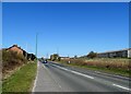
Looking along the A693 at East Castle
View west along the road past the little hamlet of East Castle. Once a small mining community but not much left now.
Image: © Robert Graham
Taken: 16 Apr 2021
0.05 miles
2
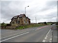
Crossroads at East Castle
This is the junction of Pontop Pike Lane, on the left, with the main road to Stanley, the A693. East Castle House here is almost all that remains of the pit village which stood here until the 1950's.
Image: © Robert Graham
Taken: 9 Apr 2014
0.06 miles
3
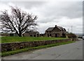
East Castle House
Viewed from the north, looking down Pontop Pike Lane. Little remains at East Castle now, but there was a pit village here in the C19 and early C20.
Image: © Robert Graham
Taken: 9 Apr 2014
0.06 miles
4
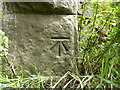
Benchmark, Stony Heap Lane Bridge
Detail of the Ordnance Survey cut benchmark on the south east abutment of Stony Heap Lane railway bridge. The benchmark marks a height of 243.618m above sea level (Ordnance Datum Newlyn) last verified in 1961 (location photograph Image).
The bridge now carries the Consett and Sunderland Railway Path.
Image: © Adrian Taylor
Taken: 10 Aug 2020
0.08 miles
5
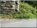
Stony Heap Lane Bridge abutment
Detail of the base of the south east abutment of Stony Heap Lane Bridge, East Castle.
There is an Ordnance Survey cut benchmark on one of the stone quoins, almost hidden by the grass and nettles (photograph Image).
Image: © Adrian Taylor
Taken: 10 Aug 2020
0.08 miles
6
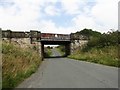
Bridge over Stoneyheap Lane
The bridge carries the old railway which is now the Consett and Sunderland Railway Path. The lane goes up to the junction with the A693 at East Castle.
Image: © Robert Graham
Taken: 26 Aug 2019
0.09 miles
7
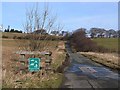
Pontop Pike Lane
In 2005 Pontop Pike Lane was designated as a "Quiet Lane" which walkers, cyclists horseriders and motor vehicles are all be expected to share with equal respect for each other's right to be there. It was the first road to be so designated in County Durham; there are some other examples throughout the country. It follows the pattern of the "Green Lanes" project in Jersey.
Two of the transmission masts at Pontop Pike can be seen on the skyline.
Image: © Oliver Dixon
Taken: 28 Feb 2014
0.09 miles
8
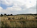
Hay bales at East Castle
In a field on the east side of Pontop Pike Lane. The distant view is of the Loud Bank at Annfield Plain.
Image: © Robert Graham
Taken: 26 Aug 2019
0.10 miles
9
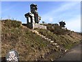
The Old Transformers
The old Stanhope and Tyne railway (also known at one point in its history as the Pontop and South Shields Railway) was built to supply the Consett Ironworks with raw material, with a link to the coast. This section of the line was one of the oldest in the country, built in 1834. The track was lifted by 1985.
The Consett and Sunderland path (part of the famous C2C cycle route, National Cycle Network route 7) follows the line of the old railway from Stanhope Moor down to Washington.
A number of giant sculptures have been erected along the path, commemorating the industrial heritage of the area. These sculpture, created from parts of old transformers are sited at Eastcastle, and represent the iron industry (nearest) and coal mining.
Image: © Oliver Dixon
Taken: 28 Feb 2014
0.10 miles
10
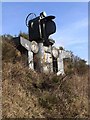
The Old Transformers - the Miner
The old Stanhope and Tyne railway (also known at one point in its history as the Pontop and South Shields Railway) was built to supply the Consett Ironworks with raw material, with a link to the coast. This section of the line was one of the oldest in the country, built in 1834. The track was lifted by 1985.
The Consett and Sunderland path (part of the famous C2C cycle route, National Cycle Network route 7) follows the line of the old railway from Stanhope Moor down to Washington.
A number of giant sculptures have been erected along the path, commemorating the industrial heritage of the area. This sculpture, created from parts of old transformers is one of two sited at Eastcastle, this one representing the coal industry, and was designed by David Kemp.
Image: © Oliver Dixon
Taken: 28 Feb 2014
0.10 miles