IMAGES TAKEN NEAR TO
Tanfield Lea Road, STANLEY, DH9 8BG
Introduction
This page details the photographs taken nearby to Tanfield Lea Road, DH9 8BG by members of the Geograph project.
The Geograph project started in 2005 with the aim of publishing, organising and preserving representative images for every square kilometre of Great Britain, Ireland and the Isle of Man.

There are currently over 7.5m images from over14,400 individuals and you can help contribute to the project by visiting https://www.geograph.org.uk
Image Map
Images are licensed for reuse under creativecommons.org/licenses/by-sa/2.0
Notes
- Clicking on the map will re-center to the selected point.
- The higher the marker number, the further away the image location is from the centre of the postcode.
Image Listing (17 Images Found)
Images are licensed for reuse under creativecommons.org/licenses/by-sa/2.0
Image
Details
Distance
1
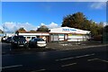
Tony's Tyres, Stanley
An alliteratively named garage providing a car maintenance service on the edge of Stanley.
Image: © Graham Robson
Taken: 28 Oct 2018
0.03 miles
2
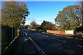
Tanfield Lea Road
Tanfield Lea Road's crossing over Houghall Burn can be identified by the brick abutments on either side of the road.
Image: © Graham Robson
Taken: 28 Oct 2018
0.04 miles
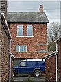
3
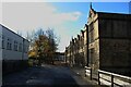
Tanfield School, Stanley
An old stone school building on the right, a slightly more modern rendered building on the left.
Image: © Graham Robson
Taken: 28 Oct 2018
0.08 miles
4
Joicey Terrace in Tanfield Lea
Aged Miners Homes erected in 1912 and dedicated to Major Joicey, the local coal owner.
Image: © Robert Graham
Taken: 6 Mar 2023
0.15 miles
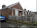
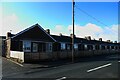
5
Joicey Terrace, Tanfield Lea
A terrace of bungalows in Tanfield Lea.
Image: © Graham Robson
Taken: 28 Oct 2018
0.16 miles
6
Jutland Terrace
This terrace in Tanfield Lea was obviously built in the 1920's as it is named after the famous sea battle of Jutland fought on the 31st May 1916 between the British and German navies.
Image: © Robert Graham
Taken: 6 Mar 2023
0.20 miles
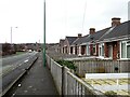
7

Good Street, Stanley
The houses on the left side of the street overlook a large playing area on the right side of the road.
Image: © Graham Robson
Taken: 28 Oct 2018
0.20 miles
8
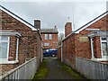
Alleyway between terraces, Tanfield Lea
The aged miners homes of Joicey Terrace, on the left and Memorial Homes on the right are separated by this entry way. These homes were built by Mrs W J Joicey in 1912 as a memorial to her husband, Major Joicey. They were local coal owners.
Image: © Robert Graham
Taken: 6 Mar 2023
0.21 miles
9
Looking along the B6173 at Tanfield Lea
Looking towards Stanley on the hill top with the tower of St Andrew's Church visible. On the right here are the aged miners bungalows of Memorial Homes. Built in 1912 by the Joicey family of local coal owners.
Image: © Robert Graham
Taken: 6 Mar 2023
0.21 miles
10

Postbox, Good Street, Stanley
A small postbox on Good Street in a residential part of Stanley.
Image: © Graham Robson
Taken: 28 Oct 2018
0.21 miles