IMAGES TAKEN NEAR TO
Boundary Lane, CONSETT, DH8 9AZ
Introduction
This page details the photographs taken nearby to Boundary Lane, DH8 9AZ by members of the Geograph project.
The Geograph project started in 2005 with the aim of publishing, organising and preserving representative images for every square kilometre of Great Britain, Ireland and the Isle of Man.

There are currently over 7.5m images from over14,400 individuals and you can help contribute to the project by visiting https://www.geograph.org.uk
Image Map
Images are licensed for reuse under creativecommons.org/licenses/by-sa/2.0
Notes
- Clicking on the map will re-center to the selected point.
- The higher the marker number, the further away the image location is from the centre of the postcode.
Image Listing (12 Images Found)
Images are licensed for reuse under creativecommons.org/licenses/by-sa/2.0
Image
Details
Distance
1
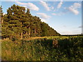
Pine Plantation adjacent to Boundary Lane
Image: © Clive Nicholson
Taken: 7 Jul 2006
0.09 miles
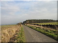
2
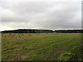
Fields and plantations south of Boundary Lane
This country lane runs west from Newlands through quite empty farming country. Most of the land is pastures or conifer plantations.
Image: © Robert Graham
Taken: 4 Nov 2019
0.09 miles
3
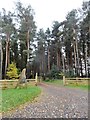
Entrance road off Boundary Lane
This drive leads to some holiday Cottages called Newlands Lodges in the plantation. Seems to be a recent development. Certainly picked a nice spot for it.
Image: © Robert Graham
Taken: 4 Nov 2019
0.09 miles
4
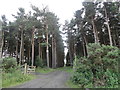
Conifer plantation
On the south side of Boundary Lane. A lot of conifers were planted in this area in the mid C19 after the enclosure of the former Newlands Common in 1808. It was thought to be a good use of the land, which was of low agricultural quality.
Image: © Robert Graham
Taken: 26 Jul 2017
0.11 miles
5
Looking down Boundary Lane
Looking East down the lane. Up to the Pine plantation in the distance, the lane is bounded by well kept hedges but past here they change to dry stone walls.
Image: © Robert Graham
Taken: 2 Mar 2012
0.15 miles
6
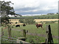
Grazing cattle
On the north side of Boundary Lane. Most of the land around here is either grazing pastures or conifer plantations. The cattle are beef animals, probably Aberdeen Angus crosses.
Image: © Robert Graham
Taken: 26 Jul 2017
0.17 miles
7
Boundary Lane
Presumably the boundary between two parishes.
Image: © Oliver Dixon
Taken: 8 Jan 2015
0.19 miles
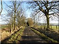
8
View up the lane
Looking west along Boundary Lane, a single track country road.
Image: © Robert Graham
Taken: 26 Jul 2017
0.20 miles
9
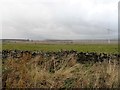
Dry stone wall
This runs along Boundary Lane and was probably first built in the early 19th century after the commons enclosure of 1808.
Image: © Robert Graham
Taken: 4 Nov 2019
0.20 miles
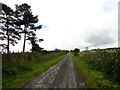
10
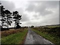
Upper end of Boundary Lane
Looking west towards the top end of the lane. Of particular notice here is the fact that the hedges which line the lane further down, change to drystone walls along this upper section.
Image: © Robert Graham
Taken: 4 Nov 2019
0.20 miles