IMAGES TAKEN NEAR TO
Bluebell Close, CONSETT, DH8 7GA
Introduction
This page details the photographs taken nearby to Bluebell Close, DH8 7GA by members of the Geograph project.
The Geograph project started in 2005 with the aim of publishing, organising and preserving representative images for every square kilometre of Great Britain, Ireland and the Isle of Man.

There are currently over 7.5m images from over14,400 individuals and you can help contribute to the project by visiting https://www.geograph.org.uk
Image Map
Images are licensed for reuse under creativecommons.org/licenses/by-sa/2.0
Notes
- Clicking on the map will re-center to the selected point.
- The higher the marker number, the further away the image location is from the centre of the postcode.
Image Listing (27 Images Found)
Images are licensed for reuse under creativecommons.org/licenses/by-sa/2.0
Image
Details
Distance
1
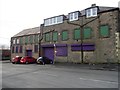
The old coop building at Leadgate
This is a view of the gable end on West Street. It shows the large doorway with originally lead into the stable yard. The stables were still in use in the 1960's to my personal knowledge. The milk deliveries to the local area were by horse and cart. The building here was opened in 1893, to replace earlier premises in the village.
Image: © Robert Graham
Taken: 20 Mar 2019
0.06 miles
2
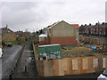
Shoddy new housing at Leadgate
The builder went bankrupt and the houses were uninhabitable. The path on the left running into the distance is the Consett and Sunderland Railway path, part of the C2C cycle route
Image: © Oliver Dixon
Taken: 18 Feb 2005
0.08 miles
3
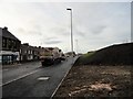
New road at Leadgate
This is Leadgate Road at the west end of the village. Formally, this crossed the old railway with a narrow bridge controlled by traffic lights. The bridge was demolished in early 2016 and the new realigned road is now nearing completion and will open in December 2016.
Image: © Robert Graham
Taken: 30 Nov 2016
0.09 miles
4
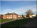
Terraced streets in Leadgate
Old terraced housing behind the main street in the village. Tindale Street is the nearest. The picture eis taken from the former railway line.
Image: © Robert Graham
Taken: 2 Nov 2016
0.11 miles
5
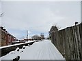
Railway path at Leadgate in the snow
This is now the Consett to Sunderland Railway Path, just behind Front Street in Leadgate village. Looking east here, near the former location of the station. The houses are in Railway Street, appropriately. Heavy snow here overnight in late February.
Image: © Robert Graham
Taken: 27 Feb 2018
0.13 miles
6
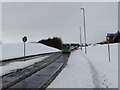
Bus in a snowy landscape at Leadgate
Looking west along the new stretch of road which replaced the old railway bridge here. The bus is Go North East's No78 service. This runs between Consett, just up the road from here , all the way to Sunderland. It must be one of the longest bus routes in the area and takes 1hr 40mins for the full journey.
Image: © Robert Graham
Taken: 27 Feb 2018
0.14 miles
7
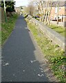
The old line at Leadgate
The former railway line just behind the main street in the village is now a footpath and cycle route. It forms part of the Consett and Sunderland Railway Path.
Image: © Robert Graham
Taken: 18 Mar 2021
0.15 miles
9
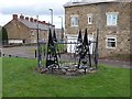
Public artwork, Leadgate
This example of public artwork has been recently erected on a small green on the site of a demolished house on Front Street, Leadgate. The Consett and Sunderland railway path (part of the famous C2C cycle route) runs on the far side of the green.
Image: © Oliver Dixon
Taken: 13 Nov 2012
0.16 miles
10
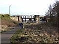
C2C at Leadgate
The old Stanhope and Tyne railway (also known at one point in its history as the Pontop and South Shields Railway) was built to supply the Consett Ironworks with raw material, with a link to the coast. This section of the line was one of the oldest in the country, built in 1834. The track was lifted by 1985.
The trackbed has now been converted to form the Consett and Sunderland path (part of the famous C2C cycle route, National Cycle Network route 7). The bridge carries the Leadgate By-pass (A692, Castleside to Chester-le-Street) road.
Image: © Oliver Dixon
Taken: 28 Feb 2014
0.17 miles