IMAGES TAKEN NEAR TO
Station View, LOCKERBIE, DG11 3LE
Introduction
This page details the photographs taken nearby to Station View, DG11 3LE by members of the Geograph project.
The Geograph project started in 2005 with the aim of publishing, organising and preserving representative images for every square kilometre of Great Britain, Ireland and the Isle of Man.

There are currently over 7.5m images from over14,400 individuals and you can help contribute to the project by visiting https://www.geograph.org.uk
Image Map
Images are licensed for reuse under creativecommons.org/licenses/by-sa/2.0
Notes
- Clicking on the map will re-center to the selected point.
- The higher the marker number, the further away the image location is from the centre of the postcode.
Image Listing (13 Images Found)
Images are licensed for reuse under creativecommons.org/licenses/by-sa/2.0
Image
Details
Distance
1
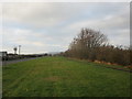
Wide verge near Eaglesfield
The B7076 was narrowed after its demotion from being the A74.
Image: © Jonathan Thacker
Taken: 21 Nov 2018
0.03 miles
2
Kirtlebridge railway station(site), Dumfries & Galloway
Opened in 1847 by the Caledonian Railway on the line from Carlisle to Glasgow, this station closed to passengers in 1960 and completely in 1964, and was demolished.
View south east towards Kirkpatrick and Carlisle. A business estate now partly occupies the site and no trace of the station apparently remains. More trees have grown in the 19 years since Image was taken from the same position.
Image: © Nigel Thompson
Taken: 10 May 2019
0.09 miles
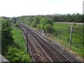
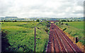
3
Site of former Kirtlebridge station, WCML 2000
View southward from B722 to the large bridge of the new A74(M). This is situated where the station had been, until it closed 13/6/60 to passengers (6/4/64 to goods). The view is up the ex-Caledonian Railway (Glasgow - Carlisle) section of the West Coast Main Line, electrified 1974. Off to the right used to be the branch line to Annan (Shawhill) and over the Solway Viaduct to Brayton on the Maryport & Carlisle Railway; this lasted to Brayton only until 20/5/21, to Annan for passengers until 27/4/31 (goods 28/2/55, however).
Image: © Ben Brooksbank
Taken: 21 Jun 2000
0.10 miles
4
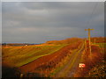
Farm track late on a winter's afternoon
Image: © Jonathan Thacker
Taken: 21 Nov 2018
0.10 miles
6
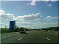
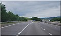
Dumfries and Galloway : The A74(M) Motorway
Looking towards the slip road from the motorway to junction 20.
Image: © Lewis Clarke
Taken: 22 Apr 2016
0.17 miles
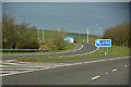
7
A74(M) Junction 20
Exit sliproad at junction 20 on the northbound A74(M)
Image: © David Dixon
Taken: 3 Apr 2017
0.18 miles
8
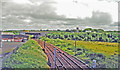
Down the West Coast Main Line at Kirtlebridge
View NW from B722 bridge, towards Beattock Summit, Carstairs and Glasgow/Edinburgh: ex-Caledonian Railway (Carlisle - Glasgow/Edinburgh) section of the WCML, electrified 1974. The view is up the Annan Valley and the flat-topped peak on the left horizon is probably Burnswark (650 ft.), with its Roman forts. (See also Image]).
Image: © Ben Brooksbank
Taken: 21 Jun 2000
0.19 miles
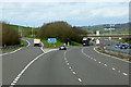
10
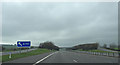
Junction 20 A74(M)
Heading north on a grey day.
Image: © wfmillar
Taken: 9 Mar 2014
0.20 miles