IMAGES TAKEN NEAR TO
DA8 2GR
Introduction
This page details the photographs taken nearby to DA8 2GR by members of the Geograph project.
The Geograph project started in 2005 with the aim of publishing, organising and preserving representative images for every square kilometre of Great Britain, Ireland and the Isle of Man.

There are currently over 7.5m images from over14,400 individuals and you can help contribute to the project by visiting https://www.geograph.org.uk
Image Map
Images are licensed for reuse under creativecommons.org/licenses/by-sa/2.0
Notes
- Clicking on the map will re-center to the selected point.
- The higher the marker number, the further away the image location is from the centre of the postcode.
Image Listing (19 Images Found)
Images are licensed for reuse under creativecommons.org/licenses/by-sa/2.0
Image
Details
Distance
1
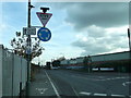
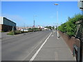
Thames Path near Manor Road roundabout, Erith
The long distance path leads along Manor Road heading towards Crayford Ness. It is also the route of the London Loop (long distance path) and the Thames Cycle Route as well.
Image: © David Anstiss
Taken: 30 Oct 2012
0.04 miles
2
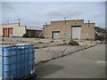
Erith: Manor Way / Slade Green Road
These derelict works buildings are at the eastern edge of Erith, at the junction of Manor Way and Slade Green Road, and are typical of several in the area where weeds, brambles and buddleia have now taken hold. The building on the right caught my eye by virtue of the large number of concrete buttresses that support both sides of the structure along its full length. Is this because the building was about to collapse or was it part of the original design that some function undertaken inside the unit could have led to a potentially calamitous event?
Update December 2011
A correspondent who used to work here in 1988 tells me that "The building with the buttresses at the side is the old GKN Chep pallet factory. This building was the spray shop where the bare wood pallets would be sprayed blue. The container in the foreground is an old paint bin. There is a building next door to this one where the pallets were made."
Image: © Nigel Cox
Taken: 2 Mar 2008
0.06 miles
3
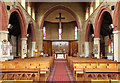
St Augustine of Canterbury, Slade Green - East end
Image: © John Salmon
Taken: 4 Jun 2014
0.06 miles
4
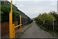
Access Lane beside the Manford Industrial Estate
The Thames Path Extension adopts this lane to reach the river from Manor Road in Erith.
Image: © Chris Heaton
Taken: 23 Oct 2016
0.07 miles
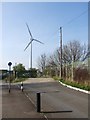
7
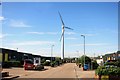
Manford Industrial Estate
On the bank of the Thames Estuary this turbine probably gets its fair share of the breeze.
Image: © Des Blenkinsopp
Taken: 4 Jun 2015
0.12 miles
9
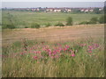
A summer's morning at Crayford Marsh
This view is from the River Thames embankment which is followed by both the Thames Path and the London LOOP. The flowers in the foreground are everlasting pea and the houses beyond Crayford Marsh are on the outskirts of Slade Green.
Image: © Marathon
Taken: 26 Jun 2010
0.13 miles
10
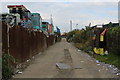
Alley heading North off Manor Road, Erith
The alley is located beside a re-cycling centre, which accounts for the copious amount of rubbish blowing across the surface.
Image: © Chris Heaton
Taken: 23 Oct 2016
0.13 miles