IMAGES TAKEN NEAR TO
Beechwood Avenue, COVENTRY, CV5 6FW
Introduction
This page details the photographs taken nearby to Beechwood Avenue, CV5 6FW by members of the Geograph project.
The Geograph project started in 2005 with the aim of publishing, organising and preserving representative images for every square kilometre of Great Britain, Ireland and the Isle of Man.

There are currently over 7.5m images from over14,400 individuals and you can help contribute to the project by visiting https://www.geograph.org.uk
Image Map
Images are licensed for reuse under creativecommons.org/licenses/by-sa/2.0
Notes
- Clicking on the map will re-center to the selected point.
- The higher the marker number, the further away the image location is from the centre of the postcode.
Image Listing (95 Images Found)
Images are licensed for reuse under creativecommons.org/licenses/by-sa/2.0
Image
Details
Distance
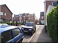
1
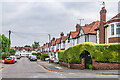
Hartington Crescent
Road first shown on the 1940 25 inch map, suggesting a building date of the 1920s or 1930s. Previous maps show the land as allotment gardens.
Image: © Ian Capper
Taken: 25 Sep 2021
0.09 miles
2
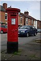
Georgian postbox, Arden Street, Earlsdon
Image: © Keith Williams
Taken: 5 May 2008
0.09 miles
3
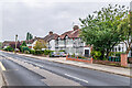
Beechwood Avenue
Road developed out of an old track named Whor Lane, first shown as Beechwood Avenue on the 1913 25 inch map. The houses here are first marked on the 1940 25 inch map, suggesting a building date of the 1920s or 1930s.
Image: © Ian Capper
Taken: 25 Sep 2021
0.10 miles
4
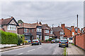
Shaftesbury Road
Road laid out in 1891. The semi-detached pair of houses in the right background of this photo is one of a group shown on the 1906 25 inch map (but marked as revised in 1894), suggesting these were the initial development. The nearer houses are not shown until the 1940 edition, suggesting a building date of the 1920s or 1930s.
Image: © Ian Capper
Taken: 25 Sep 2021
0.10 miles
5
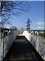
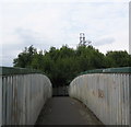
Footbridge Beechwood Ave, Coventry
The Beechwood Avenue footbridge over the Coventry to Birmingham railway line, provided to avoid risking life and limb on the blind corner, single width, no pavement road bridge out of shot on the left. As an added bonus there's the first pylon to pop up from Hearsall Common in the background.
Image: © E Gammie
Taken: 27 Apr 2006
0.11 miles
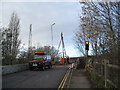
6
Beechwood Avenue bridge
Beechwood Avenue is closed again for work to replace the road surface over the bridge. The temporary concrete barriers have been removed from the left of the road and a mechanical digger is at work behind the lorry.
See also http://www.geograph.org.uk/photo/3237782 (2012).
Image: © E Gammie
Taken: 30 Jan 2013
0.11 miles
7
Beechwood Avenue bridge
Beechwood Avenue bridge, closed for the weekend whilst investigatory drilling work is carried out. I suspect they may find a railway nearby.
The approaches to the bridge are at an angle and embanked and the road, comparatively recently resurfaced, suffers from surface cracking. The bridge parapet behind where the drill is located was rebuilt two years ago and concrete barriers added at the western side of the road on both sides of the bridge. The bridge itself is a traffic-light controlled single carriageway and limited to 7.5 tons, although a bus route does cross it.
Later work: http://www.geograph.org.uk/photo/3317193 (2013)
Image: © E Gammie
Taken: 25 Nov 2012
0.11 miles
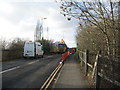
8
Arden Street seen from Clarendon Street
Image: © John Brightley
Taken: 14 Apr 2007
0.12 miles
9
Footbridge, Beechwood Avenue
The footbridge over the Coventry-Birmingham railway, adjacent to the road bridge. Young ash trees crowding in at the far end and starlings gathering on the wires.
In brighter circumstances, 2006: Image]
Image: © E Gammie
Taken: 14 Sep 2014
0.13 miles
10
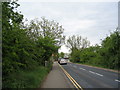
Beechwood Avenue
Looking towards the bridge over the Coventry to Birmingham railway line. The hawthorns lining the left side of the road are not yet in blossom - compare with 1st May 2011 : Image
Image: © E Gammie
Taken: 18 May 2013
0.13 miles