IMAGES TAKEN NEAR TO
Adelaide Street, COVENTRY, CV1 5GX
Introduction
This page details the photographs taken nearby to Adelaide Street, CV1 5GX by members of the Geograph project.
The Geograph project started in 2005 with the aim of publishing, organising and preserving representative images for every square kilometre of Great Britain, Ireland and the Isle of Man.

There are currently over 7.5m images from over14,400 individuals and you can help contribute to the project by visiting https://www.geograph.org.uk
Image Map
Images are licensed for reuse under creativecommons.org/licenses/by-sa/2.0
Notes
- Clicking on the map will re-center to the selected point.
- The higher the marker number, the further away the image location is from the centre of the postcode.
Image Listing (58 Images Found)
Images are licensed for reuse under creativecommons.org/licenses/by-sa/2.0
Image
Details
Distance
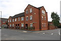
1
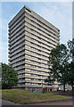
Pioneer House, Adelaide Street, Coventry
One of a number of similarly-styled tower blocks dotted about the northern fringes of Coventry, standing like sentries as if to provide early warning of incursions by Nuneaton or Hinckley. They are distinguished by projecting white concrete bands and closely resemble designs by City Architect, Arthur Ling. Built by him or his successor, Terence Gregory, in the early-mid 1960s.
Image: © Stephen Richards
Taken: 22 Aug 2011
0.01 miles
2
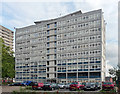
Paul Stacey House, Bath Street, Coventry
Similar to a number of slabs west of the city by the City Architect, Arthur Ling, c1960. Pevsner comments that they are in the London County Council style and remarks on the "butterfly excrescences on top".
All this is owned by Whitefriars Housing, Coventry's largest social landlord.
Image: © Stephen Richards
Taken: 22 Aug 2011
0.05 miles
3
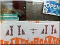
Persepolis paper in window of Iranian delicatessen, Hillfields, Coventry
This is a detail from the window display of the Persian Mini Market delicatessen in Victoria Street that appears in this geograph Image], though from a photo taken over two years earlier; the paper has since become very faded. It was taken on the 19th March, and the shop and its customers were busy preparing for Nowruz, the Iranian New Year, which is celebrated at the spring equinox.
The paper is printed with repeating patterns showing the ruins of Persepolis, the royal palace complex built by the kings of the Achaemenid dynasty of the 6th to 4th century BCE, and burned down by Alexander of Macedon ('Alexander the Great') during his conquest of Persia in 331BCE. Persepolis is the Greek name; it was known to Persians as Parsa, and is called Takht-e-Jamshid (the throne of Jamshid) by modern Iranians. The ruins still stand in the vicinity of the city of Shiraz and are an important non-Islamic symbol of Iranian identity, as is the figure on the winged disc in the centre of the pattern, known today as the Faravahar. At Persepolis this represented either kingly glory ('khvarenah') or the god Ahuramazda, and as a modern symbol of Zoroastrian religion and Iranian culture it is often identified with the fravashi or personal spirit. See Curtis J, Sarikhani Sandmann, I & Stanley, T, Epic Iran: 5000 Years of Culture, V&A Publishing, 2021, pp62-65, also the Wikipedia article on the Faravahar here https://en.wikipedia.org/wiki/Faravahar .
Image: © A J Paxton
Taken: 19 Mar 2019
0.05 miles
4
Hillfields-Victoria Street
Shops including the Post Office.
Image: © Ian Rob
Taken: 20 Jul 2013
0.05 miles
5
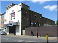
Mint Casino
This building was the Palladium cinema from 1915 until 1982.
Image: © Keith Williams
Taken: 11 Jun 2015
0.05 miles
6
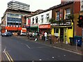
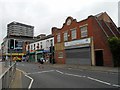
Victoria Street, Hillfields, Coventry
This part of Victoria Street forms the southern side of a square at the centre of the rather edgy social life of Hillfields. It was created as part of the 'regeneration' of the area at the tun of the century, when most of its thirteen tower blocks were demolished and replaced by low-rise housing. https://www.coventrysociety.org.uk/coventry-neighbourhoods/hillfields.html
In this row of buildings can be seen an Iranian delicatessen, the Persian Mini Market. Like many such specialist shops it has expanded its range to cater for other communities that live and shop locally; on its shelves I saw Riga herrings and tinned elk meat among more familiar Iranian foodstuffs. On this hot and humid July evening it was doing a brisk trade in melons. Beyond it can be seen two Kurdish shops, the Yosuf Bakery and the Kurdistan Coffee Shop.
The First and Best food store on the far side of Canterbury Street occupies the now very decrepit-looking premises built in the early 1960s by H E Phillips, a specialist ironmonger, whose sign is still visible on the first floor. This family firm traded in Hillfields for ninety years from 1915 (see this IPPR report pp6-7 https://www.ippr.org/files/images/media/files/publication/2011/05/making_sense_of_community_1272.pdf ), and its expertise and its pegboards hung with countless tools and other useful items have been much missed by Coventry people. Behind it stands Thomas King House, one of the surviving 1960s housing blocks.
Image: © A J Paxton
Taken: 22 Jul 2021
0.06 miles
7
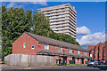
Victoria Street
Late 1990s redevelopment in Victoria Street. In the background is Pioneer House, a 17 storey block of flats completed in 1966.
Image: © Ian Capper
Taken: 24 Sep 2021
0.06 miles
8
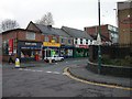
Coventry-Hillfields
Shops in Victoria Street.
Image: © Ian Rob
Taken: 7 Dec 2007
0.08 miles
9
Housing block on Victoria Street at Vine Street junction
I suspect this is a new build on the site of a School of Art building and perhaps the decorative stones on the Vine Street face (which include the letters A and D) where taken from that previous building
Image: © Roger Templeman
Taken: 17 Aug 2018
0.09 miles
10
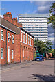
Charles Street
19th Century housing in Charles Street. Nos 1 - 3, in the centre of the photo, are grade II listed - see www.historicengland.org.uk/listing/the-list/list-entry/1076638. In the background is Thomas King House, a 17 storey block of flats completed in 1968.
Image: © Ian Capper
Taken: 24 Sep 2021
0.09 miles