Victoria Street, Hillfields, Coventry
Introduction
The photograph on this page of Victoria Street, Hillfields, Coventry by A J Paxton as part of the Geograph project.
The Geograph project started in 2005 with the aim of publishing, organising and preserving representative images for every square kilometre of Great Britain, Ireland and the Isle of Man.

There are currently over 7.5m images from over 14,400 individuals and you can help contribute to the project by visiting https://www.geograph.org.uk
Victoria Street, Hillfields, Coventry
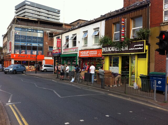
Image: © A J Paxton Taken: 22 Jul 2021
This part of Victoria Street forms the southern side of a square at the centre of the rather edgy social life of Hillfields. It was created as part of the 'regeneration' of the area at the tun of the century, when most of its thirteen tower blocks were demolished and replaced by low-rise housing. https://www.coventrysociety.org.uk/coventry-neighbourhoods/hillfields.html In this row of buildings can be seen an Iranian delicatessen, the Persian Mini Market. Like many such specialist shops it has expanded its range to cater for other communities that live and shop locally; on its shelves I saw Riga herrings and tinned elk meat among more familiar Iranian foodstuffs. On this hot and humid July evening it was doing a brisk trade in melons. Beyond it can be seen two Kurdish shops, the Yosuf Bakery and the Kurdistan Coffee Shop. The First and Best food store on the far side of Canterbury Street occupies the now very decrepit-looking premises built in the early 1960s by H E Phillips, a specialist ironmonger, whose sign is still visible on the first floor. This family firm traded in Hillfields for ninety years from 1915 (see this IPPR report pp6-7 https://www.ippr.org/files/images/media/files/publication/2011/05/making_sense_of_community_1272.pdf ), and its expertise and its pegboards hung with countless tools and other useful items have been much missed by Coventry people. Behind it stands Thomas King House, one of the surviving 1960s housing blocks.
Images are licensed for reuse under creativecommons.org/licenses/by-sa/2.0
Image Location
Latitude
52.413252
Longitude
-1.499944