IMAGES TAKEN NEAR TO
Middleborough Road, COVENTRY, CV1 4DD
Introduction
This page details the photographs taken nearby to Middleborough Road, CV1 4DD by members of the Geograph project.
The Geograph project started in 2005 with the aim of publishing, organising and preserving representative images for every square kilometre of Great Britain, Ireland and the Isle of Man.

There are currently over 7.5m images from over14,400 individuals and you can help contribute to the project by visiting https://www.geograph.org.uk
Image Map
Images are licensed for reuse under creativecommons.org/licenses/by-sa/2.0
Notes
- Clicking on the map will re-center to the selected point.
- The higher the marker number, the further away the image location is from the centre of the postcode.
Image Listing (428 Images Found)
Images are licensed for reuse under creativecommons.org/licenses/by-sa/2.0
Image
Details
Distance
1
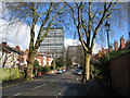
Middleborough Road
Late 19th/early 20th century housing in Middleborough Road contrasts with the 1960s tower blocks of Naul's Mill House and Samuel Vale House at the far end of the road.
Image: © E Gammie
Taken: 1 Mar 2016
0.02 miles
2
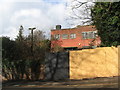
Former social club
The former Coventry Brassworkers Club in Middleborough Road has been derelict for some years.
Image: © E Gammie
Taken: 1 Mar 2016
0.02 miles
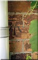
3
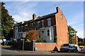
Nos. 29, 31, 33 and 35 Middleborough Road
There is an Ordnance Survey benchmark Image on the front face of the nearest house at its corner right of the grey downpipe and inside the brick boundary wall.
Image: © Roger Templeman
Taken: 19 Sep 2017
0.03 miles
4
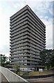
Nauls Mill House, Middleborough Road, Coventry
One of a number of similarly-styled tower blocks dotted about the northern fringes of Coventry, standing like sentries as if to provide early warning of incursions by Nuneaton or Hinckley. They are distinguished by projecting white concrete bands. This was built in 1968 by Terence Gregory, City Architect.
Taken from a footbridge over Coventry's apparently omnipresent ring road.
Image: © Stephen Richards
Taken: 22 Aug 2011
0.04 miles
5
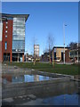
Belgrade Plaza, Upper Well Street
Looking across Belgrade Plaza and Upper Well Street towards Naul's Mill House tower block.
Image: © E Gammie
Taken: 9 Mar 2017
0.04 miles
6
Benchmark on #35 Middleborough Road
Ordnance Survey cut mark benchmark described on the Bench Mark Database at www.bench-marks.org.uk/bm89755
Image: © Roger Templeman
Taken: 19 Sep 2017
0.04 miles
7
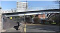
Footbridge crossing Radford Road
Footbridge traversing the Radford Road dual carriageway, where its concrete-sided cutting bisects the older Middleborough Road, with its Victorian houses. The photo is taken from the western half of Middleborough Road looking east towards Samuel Vale House, the housing block visible behind the bridge. The near side of the bridge connects with the forecourt of Naul's Mill House, off to the left of the photo, a tower block very similar in design to Samuel Vale House. Bridge, cutting and dual carriageway would have been built around 1964, along with the section of the ring road off to the right of the picture that connects with Radford Road by a roundabout. https://www.historiccoventry.co.uk/postwar/postwar.php?pg=develop The tower blocks were built shortly afterwards. https://www.towerblock.eca.ed.ac.uk/development/st-nicholas-street The footbridge overlooks the ring road, with its roundabout and flyover, and the adjoining part of the city centre around the Belgrade Theatre. The footbridge is useful for getting from densely built-up inner Radford to Naul's Mill Park.
Image: © A J Paxton
Taken: 9 Mar 2014
0.04 miles
8
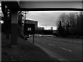
Stay Home: Essential Travel Only
This is Radford Road, looking towards the city centre, during the first Covid-19 pandemic lockdown, towards the end of March 2020. The photographer was doing essential food shopping and had just got off the bus that can be seen beyond the sign.
Image: © A J Paxton
Taken: 28 Mar 2020
0.05 miles
9
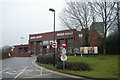
Coventry fire station
Coventry fire station, Radford Road, Coventry, West Midlands
Image: © Kevin Hale
Taken: 25 Jan 2009
0.05 miles
10
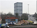
Fire station and Naul's Mill House
The 1970's fire station at the junction of Radford Road and Ringway Hill Cross undergoing demolition. It is to be replaced with an updated station on the same site. Naul's Mill House residential tower block stands in the background.
In 2007: Image]
Image: © PGJ
Taken: 15 Feb 2017
0.05 miles