Footbridge crossing Radford Road
Introduction
The photograph on this page of Footbridge crossing Radford Road by A J Paxton as part of the Geograph project.
The Geograph project started in 2005 with the aim of publishing, organising and preserving representative images for every square kilometre of Great Britain, Ireland and the Isle of Man.

There are currently over 7.5m images from over 14,400 individuals and you can help contribute to the project by visiting https://www.geograph.org.uk
Footbridge crossing Radford Road
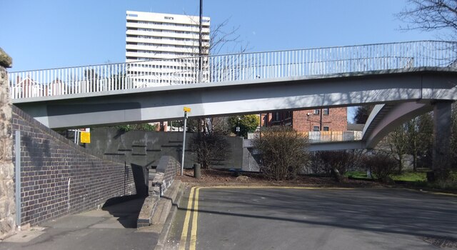
Image: © A J Paxton Taken: 9 Mar 2014
Footbridge traversing the Radford Road dual carriageway, where its concrete-sided cutting bisects the older Middleborough Road, with its Victorian houses. The photo is taken from the western half of Middleborough Road looking east towards Samuel Vale House, the housing block visible behind the bridge. The near side of the bridge connects with the forecourt of Naul's Mill House, off to the left of the photo, a tower block very similar in design to Samuel Vale House. Bridge, cutting and dual carriageway would have been built around 1964, along with the section of the ring road off to the right of the picture that connects with Radford Road by a roundabout. https://www.historiccoventry.co.uk/postwar/postwar.php?pg=develop The tower blocks were built shortly afterwards. https://www.towerblock.eca.ed.ac.uk/development/st-nicholas-street The footbridge overlooks the ring road, with its roundabout and flyover, and the adjoining part of the city centre around the Belgrade Theatre. The footbridge is useful for getting from densely built-up inner Radford to Naul's Mill Park.
Images are licensed for reuse under creativecommons.org/licenses/by-sa/2.0
Image Location
Latitude
52.413226
Longitude
-1.515381