IMAGES TAKEN NEAR TO
Windsor Street, COVENTRY, CV1 3EQ
Introduction
This page details the photographs taken nearby to Windsor Street, CV1 3EQ by members of the Geograph project.
The Geograph project started in 2005 with the aim of publishing, organising and preserving representative images for every square kilometre of Great Britain, Ireland and the Isle of Man.

There are currently over 7.5m images from over14,400 individuals and you can help contribute to the project by visiting https://www.geograph.org.uk
Image Map
Images are licensed for reuse under creativecommons.org/licenses/by-sa/2.0
Notes
- Clicking on the map will re-center to the selected point.
- The higher the marker number, the further away the image location is from the centre of the postcode.
Image Listing (487 Images Found)
Images are licensed for reuse under creativecommons.org/licenses/by-sa/2.0
Image
Details
Distance
1
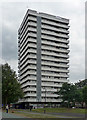
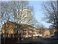
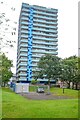
Meadow House, Upper Spon Street, Coventry
One of a number of similarly-styled tower blocks dotted about the northern fringes of Coventry, standing like sentries as if to provide early warning of incursions by Nuneaton or Hinckley. They are distinguished by projecting white concrete bands and closely resemble designs by City Architect, Arthur Ling. Built by him or his successor, Terence Gregory, in the early-mid 1960s.
Image: © Stephen Richards
Taken: 22 Aug 2011
0.05 miles
2
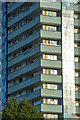
Coventry : Meadow House
A 17-storey block containing 130 dwellings completed in 1967.
Image: © Lewis Clarke
Taken: 25 Sep 2021
0.05 miles
3
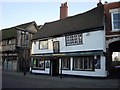
The Old Windmill, Spon Street, Coventry
The Old Windmill in Spon Street, Coventry can trace its history back to around 1580. Mentioned in Hewitt 1756, it was said to have been erected around the trunk of a tree and is one of the oldest taverns in Coventry. The uneven exterior walls are wattle and daub and until recent years little was done to change its character. During the 1980s there was some modernisation and the central paved courtyard was roofed over and a wall removed.
Image: © Sue Adair
Taken: 4 Feb 2003
0.05 miles
4
Meadow House and Spon Street
Meadow House residential tower block dominates Spon Street and was built in 1966 alongside the ring road that sliced through Spon Street at much the same time. The exterior was refurbished in a light blue ca. 2013. Other buildings visible are (on the left) part of the former Rotherhams offices, some of which date from the 18th century and a 1990s entertainment complex built on the site of the former Rudge (later GEC) factory. On the right are timber framed buildings dating from the 15th century.
Meadow House in 2011: Image]
Image: © E Gammie
Taken: 23 Dec 2015
0.05 miles
5
The Sherbourne at Spon End
Taken in 1972, when the area had been recently re-landscaped. The footbridge is a former canal bridge, removed here from near Sowe Common during the building of the M6. Beyond is the Ringway Rudge section of the inner ring road and the furthest building on the left was the GEC factory, previously Rudge-Whitworth and now demolished. The spire is that of Greyfriars/Christ Church, one of Coventry's three spires.
Image: © FCG
Taken: Unknown
0.05 miles
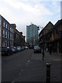
6
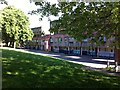
Housing in Coventry
These houses are close to the centre of Coventry. Coventry's ring road passes just to the right, out of sight in the image.
Image: © Malc McDonald
Taken: 13 Jan 2013
0.05 miles
7
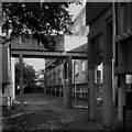
Streets in the Sky, Spon End
A concrete walkway connects the upper rows of two-storey maisonettes in the four storey blocks of Milestone House, Kerry's House & Trafalgar House in Spon End, Coventry. The maisonettes were built in the 1960s by the City Architect's Department under Arthur Ling as part of a programme of slum clearance; see Image] for further information.
The maisonettes are themselves now to be demolished and replaced in a programme beginning in 2023, as reported by the Coventry Society https://news.coventrysociety.org.uk/2022/05/16/redevelopment-of-spon-end/ . Many are now empty and boarded up, though others are still lived-in.
For the unhappy history of 'streets in the sky' see the Urban Idiot writing for the Academy of Urbanism https://www.academyofurbanism.org.uk/streets-in-the-sky-the-urban-idiot/ . Spon End is at least on a smaller scale than the vast blocks of Park Hill in Sheffield and Hulme in Manchester.
Image: © A J Paxton
Taken: 1 Oct 2022
0.05 miles
8
Maisonettes, Upper Spon Street, Spon End, Coventry
Spon End was an early suburb of Coventry that developed along the road to Birmingham beyond the Spon Gate on the western side of the city. It became a quarter of tanners and dyers, who used the waters of the River Sherbourne; by the 19th century watchmaking had also become important. https://en.wikipedia.org/wiki/Spon_Street
Spon End became known as a slum; in the 1952 Development Plan for Coventry, the city's chief architect Donald Gibson wrote that it had “some of the worst housing conditions in the city… [with] the worst possible lightning [sic] and ventilation… Sanitary facilities are highly unsatisfactory.” https://sponend.wordpress.com/2018/08/06/buildings/ The planners' response was to compulsorily purchase and demolish most of the existing housing and replace it with a mixture of two-storey houses and low-rise and high-rise flats and maisonettes. Gibson's successor Arthur Ling modified the plan in 1957, favouring more high-rise housing.
The Wimpey construction company completed the development in eight years in the 1960s, using the 'no-fines' construction method. These maisonettes are typical of the development. They have flat roofs, walkways connecting blocks at second floor level, and exterior walls of very plain unadorned concrete incised with vertical lines.
Image: © A J Paxton
Taken: 12 Jun 2021
0.05 miles
9
Coventry : Meadow House
Looking towards Meadow House.
Image: © Lewis Clarke
Taken: 24 Sep 2021
0.05 miles
10
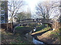
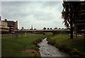
Vignoles bridge, Coventry
This iron footbridge contrasts with the postwar buildings which surround it. The bridge, which dates from the 1830s, originally spanned the Oxford Canal. It was moved to its current location over the River Sherbourne in around 1969 or 1970. It is designated as a Scheduled Ancient Monument.
Image: © Malc McDonald
Taken: 13 Jan 2013
0.05 miles