IMAGES TAKEN NEAR TO
Humber Avenue, COVENTRY, CV1 2AQ
Introduction
This page details the photographs taken nearby to Humber Avenue, CV1 2AQ by members of the Geograph project.
The Geograph project started in 2005 with the aim of publishing, organising and preserving representative images for every square kilometre of Great Britain, Ireland and the Isle of Man.

There are currently over 7.5m images from over14,400 individuals and you can help contribute to the project by visiting https://www.geograph.org.uk
Image Map
Images are licensed for reuse under creativecommons.org/licenses/by-sa/2.0
Notes
- Clicking on the map will re-center to the selected point.
- The higher the marker number, the further away the image location is from the centre of the postcode.
Image Listing (92 Images Found)
Images are licensed for reuse under creativecommons.org/licenses/by-sa/2.0
Image
Details
Distance
1
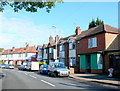
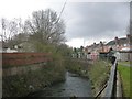
Humber Avenue
This is Humber avenue viewed from the bottom end where the road terminates where it crosses a bridge over the river Sherbourne. The shop on the right which is now closed was once a general food store.
Image: © Nigel Mykura
Taken: 11 Jun 2011
0.01 miles
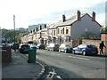
2
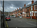
Coventry-Humber Avenue
Terraced housing on Humber Avenue.
Image: © Ian Rob
Taken: 14 Apr 2008
0.01 miles
3
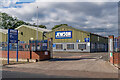
Jewson's
Builders' merchant on Humber Avenue.
Image: © Ian Capper
Taken: 24 Sep 2021
0.03 miles
4
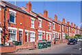
Humber Avenue
Early 20th Century housing, first appearing on the 1914 25 inch map.
Image: © Ian Capper
Taken: 24 Sep 2021
0.03 miles
5
Coventry-River Sherbourne
Part of the river running to the rear of Strathmore Avenue.
Image: © Ian Rob
Taken: 14 Apr 2008
0.04 miles
6
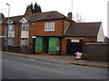
Former shop, Humber Avenue
One of many that have closed in the area.
One would speculate that this was a grocers.
The orange strip if I remember correctly was a Brook Bond tea advertisement.
Image: © Anthony Vosper
Taken: 16 Feb 2012
0.04 miles
7
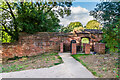
Precinct wall, Charterhouse
Part of the medieval precinct wall to the Carthusian Priory, the Charterhouse, one of 9 in England, with building dating from the late 14th to early 15th Centuries. Grade II* listed - see www.historicengland.org.uk/listing/the-list/list-entry/1342917.
Image: © Ian Capper
Taken: 24 Sep 2021
0.04 miles
8
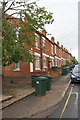
Houses and wheelie bins on north side of Humber Avenue
Ordnance Survey documents indicate that in 1959 a benchmark levelled at 75.383m above Newlyn Datum was verified on the wall fronting the nearest house (#184). The wall appears to have been rebuilt
Image: © Roger Templeman
Taken: 8 Aug 2017
0.05 miles
9
Houses descending the east side of the Sherbourne valley
Humber Avenue, Coventry. The houses were built between 1903 and 1912.
Image: © Christine Johnstone
Taken: 24 Sep 2021
0.05 miles
10
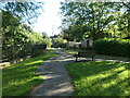
Bench by the River Sherbourne, Coventry
By the east bank of the river, heading south from Acacia Avenue.
Image: © Christine Johnstone
Taken: 24 Sep 2021
0.06 miles