IMAGES TAKEN NEAR TO
Lairage Close, DOVER, CT15 7GY
Introduction
This page details the photographs taken nearby to Lairage Close, CT15 7GY by members of the Geograph project.
The Geograph project started in 2005 with the aim of publishing, organising and preserving representative images for every square kilometre of Great Britain, Ireland and the Isle of Man.

There are currently over 7.5m images from over14,400 individuals and you can help contribute to the project by visiting https://www.geograph.org.uk
Image Map
Images are licensed for reuse under creativecommons.org/licenses/by-sa/2.0
Notes
- Clicking on the map will re-center to the selected point.
- The higher the marker number, the further away the image location is from the centre of the postcode.
Image Listing (64 Images Found)
Images are licensed for reuse under creativecommons.org/licenses/by-sa/2.0
Image
Details
Distance
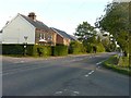
1
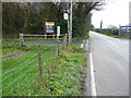
Lairage Cottages, Swingfield Minnis
The vehicular access Image to these houses is half way along the road straight ahead, which provides a link between Canterbury Road (A260) and the road to Lydden and Dover. Six months ago, this development appeared as Image The dictionary meaning of ‘lairage’ is a place where cattle are housed.
Image: © John Baker
Taken: 15 Apr 2012
0.01 miles
2
Residential development, Swingfield Minnis
The site is on land adjoining Swingfield House. Planning permission has been approved, with conditions, by Folkestone and Hythe District Council under application number Y09/0738/SH for the “erection of 6 affordable housing units and provision of new access road”. It appears from the related documents for this planning application that an abattoir one stood on the site, which would have meant that other buildings could be erected, bearing in mind that there are constraints for new buildings in areas of outstanding natural beauty (under which this site falls). The dictionary meaning of ‘lairage’ is a place where cattle are housed. The development also includes provision for a new access road which will emerge onto the lane near the electricity pole. Before the development started, this corner of the site appeared as Image
Image: © John Baker
Taken: 5 Oct 2011
0.01 miles
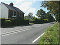
3
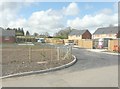
Lairage Close, Swingfield Minnis
The landscaping was completed during the last week of March 2012. The dictionary meaning of ‘lairage’ is a place where cattle are housed.
Image: © John Baker
Taken: 15 Apr 2012
0.01 miles
4
Lairage Cottages, Swingfield Minnis
When I last took these houses, the roofs were under construction Image and they had not been given a name. The houses are well served by buses from Canterbury and Hythe, via Folkestone, as there is a bus stop, with a shelter, almost ‘outside the door’, for passengers wishing to travel to Folkestone and Hythe and a stop on the opposite side of the road for those wishing to travel to Canterbury. The service runs every 15 minutes from just after 09:00 to 17:10 (to Folkestone and Hythe) and up to 18:30 from the Canterbury direction. After those times, the service is less frequent. The dictionary meaning of ‘lairage’ is a place where cattle are housed.
Image: © John Baker
Taken: 12 May 2012
0.02 miles
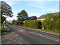
5
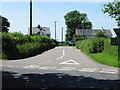
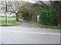
Canterbury Road (A260), Swingfield Minnis
The scaffolding that can be seen in this view is for the erection of six affordable housing units on land adjoining Swingfield House. Planning permission has been approved, with conditions, by Folkestone and Hythe District Council under application number Y09/0738/SH for the “erection of 6 affordable housing units and provision of new access road”. The house to the left is semi-detached; the left half is called New Cottage and the right: Omar.
Image: © John Baker
Taken: 22 Jul 2011
0.03 miles
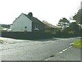
6
Lairage Cottages, Swingfield Minnis
Lairage Cottages are well served by buses from Canterbury and Hythe, via Folkestone, as there is a bus stop, with a shelter, almost ‘outside the door’, for passengers wishing to travel to Folkestone and Hythe and a stop on the opposite side of the road for those wishing to travel to Canterbury. The service runs every 15 minutes from just after 09:00 to 17:10 (to Folkestone and Hythe) and up to 18:30 from the Canterbury direction. After those times, the service is less frequent. This picture was taken looking across Canterbury Road (A260) on a exceptionally cold evening for mid-May. The dictionary meaning of ‘lairage’ is a place where cattle are housed.
Image: © John Baker
Taken: 12 May 2012
0.03 miles
7
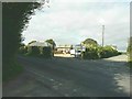
Canterbury Road (A260), Swingfield Minnis
Two months after taking Image the construction of the buildings on this site has reached the installation of the roof rafters
Image: © John Baker
Taken: 25 Sep 2011
0.03 miles
8
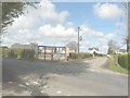
Landwood Group ?for sale? board
Another board has been affixed to the main gate of the Image by the company http://www.landwoodgroup.com/property-item/former-macfarlanes-nurseries-canterbury-road-swingfield-dover-ct15-7hx/ The board has the following information “former garden centre with various buildings extending to 18.4 acres (7.4 hectares)”. There are also two telephone numbers, which can be found in the link. This view shows that the former garden centre extended from the corner of the crossroads and down the road ahead, as far as the eye could see.
Image: © John Baker
Taken: 27 Nov 2015
0.03 miles
9
Landwood Group ?for sale? board
Another board has been affixed to the main gate of the Image by the company http://www.landwoodgroup.com/property-item/former-macfarlanes-nurseries-canterbury-road-swingfield-dover-ct15-7hx/ The board has the following information “former garden centre with various buildings extending to 18.4 acres (7.4 hectares)”. There are also two telephone numbers, which can be found in the link. This view shows that the former garden centre extended from the corner of the crossroads to the end of the road ahead.
Image: © John Baker
Taken: 27 Nov 2015
0.03 miles