IMAGES TAKEN NEAR TO
Walton Road, CLACTON-ON-SEA, CO15 6DZ
Introduction
This page details the photographs taken nearby to Walton Road, CO15 6DZ by members of the Geograph project.
The Geograph project started in 2005 with the aim of publishing, organising and preserving representative images for every square kilometre of Great Britain, Ireland and the Isle of Man.

There are currently over 7.5m images from over14,400 individuals and you can help contribute to the project by visiting https://www.geograph.org.uk
Image Map (Loading...)


Getting Data...Please wait
Leaflet Map data © OpenStreetMap
Images are licensed for reuse under creativecommons.org/licenses/by-sa/2.0
Notes
- Clicking on the map will re-center to the selected point.
- The higher the marker number, the further away the image location is from the centre of the postcode.
Image Listing (12 Images Found)
Images are licensed for reuse under creativecommons.org/licenses/by-sa/2.0
Image
Details
Distance
1
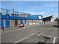
Leisure centre, Clacton
This is the entrance (the set of blue doors furthest to right, beneath the sloping roof) to Clacton Leisure Centre, which was built in 1987. The picture was taken from the car park.
Image: © Duncan Graham
Taken: 16 Feb 2018
0.09 miles
2
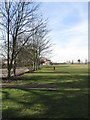
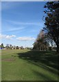
Recreation ground, Clacton
A view of the southern part of the recreation ground, taken from the south-eastern corner.
To the left in the foreground is a fence marking the boundary with Clacton County High School. Just beyond the trees on the left are buildings belonging to Clacton Leisure Centre; in the far distance on the horizon is the railway line, the footbridge painted green being visible. To the right on the horizon, just visible beyond the railway line, are buildings on the industrial estate on Oxford Road and beyond them housing.
See Image taken at the same time.
Image: © Duncan Graham
Taken: 16 Feb 2018
0.13 miles
3
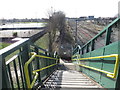
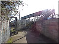
View from footbridge
Taken from the footbridge which crosses the railway line north-east of Clacton Railway Station, connecting Oxford Road with Clacton Leisure Centre and the recreation ground. To the right of picture is the railway line, with buildings on the industrial estate on Oxford Road visible. To the left are tennis courts forming part of the grounds of the leisure centre, with a children's play area beyond. Housing can be seen near the horizon.
The footbridge is marked "FB" on Ordnance Survey maps. See Image and Image
Image: © Duncan Graham
Taken: 16 Feb 2018
0.15 miles
4
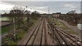
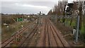
Clacton-on-Sea: Railway lines approaching Clacton-on-Sea station
The trackwork is viewed here from the Oxford Road footbridge, looking towards Clacton-on-Sea station. Old large scale Ordnance Survey maps show that there were at least 6 parallel tracks through here when the railway was at its peak.
Image: © Nigel Cox
Taken: 15 Mar 2020
0.17 miles
5
Footbridge, Oxford Road, Clacton (close up)
This is a close-up of the footbridge over the railway line on Oxford Road, Clacton, the entrance to which is shown from the opposite pavement in Image Beyond the railway line are Clacton Leisure Centre, its grounds and the neighbouring recreation ground.
The footbridge is indicated on Ordnance Survey maps by the abbreviation FB.
Image: © Duncan Graham
Taken: 16 Feb 2018
0.19 miles
6
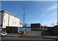
Telecommunications mast, Oxford Road
A telecommunications mast, between the industrial estate on Oxford Road and the railway line behind.
Photographed from the opposite pavement on Oxford Road.
The mast formerly supported two satellite dishes, visible in 2009.
Image: © Duncan Graham
Taken: 16 Feb 2018
0.19 miles
7
Recreation ground, Clacton
A view of the south-eastern part of the public recreation ground, taken from the far south-eastern corner looking roughly north-east.
The metal fence to the right in the foreground and immediately behind when I took the photograph marks the boundary of Clacton County High School grounds. In the distance are houses on Wyndham Crescent and a telecommunications mast on Valleybridge Road.
See Image taken at the same time.
Image: © Duncan Graham
Taken: 16 Feb 2018
0.19 miles
8
Clacton-on-Sea: Railway lines leaving Clacton-on-Sea station
The trackwork is viewed here from the Oxford Road footbridge, looking away from Clacton-on-Sea station. Old large scale Ordnance Survey maps show that the engine shed used to be on the concrete pad to the left where the green containers are now. Zooming into the photograph shows that the trackwork is still extant there.
Image: © Nigel Cox
Taken: 15 Mar 2020
0.21 miles
9

Footbridge, Oxford Road, Clacton
The photograph shows the entrance on Oxford Road, Clacton, to a footbridge over the railway line, taken from the opposite pavement of the street.
Oxford Road runs through an industrial estate and premises belonging to a business are visible at either side of the unobtrusive footbridge entrance, which is between the metal fencing at centre of picture.
Image: © Duncan Graham
Taken: 16 Feb 2018
0.22 miles
10
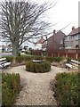
Memorial garden to Mr and Mrs F W Gill and the German air crew
This is a small memorial garden in Clacton, on the northern corner where Victoria Road and Albert Gardens intersect. On 30th April 1940, a German Heinkel bomber carrying sea mines crash-landed on the house in Victoria Road belonging to Mr Frederick W Gill (b. 1888), a retired wool merchant, and his wife Dorothy (b. 1894). The house was utterly destroyed and they were both killed. They were the first civilian casualties of World War II on the British mainland. The memorial commemorates both them and the four members of the German air crew.
The crash also made fifty houses uninhabitable and 156 people were injured. The Gills' 19-year-old son William survived with head
injuries.
The memorial was refurbished and a new memorial stone added in April 2017, paid for partly by money remaining from an air disaster fund set up in 1940 following the crash by the Rev H G Redgrave, the chairman of Clacton Urban District Council.
[Sources: bbc.co.uk; Chelmsford Chronicle, 3rd May 1940, from the British Newspaper Archive and courtesy of the British Library Board; National Register 1939 entry for the Gills].
Image: © Duncan Graham
Taken: 20 Feb 2018
0.24 miles