IMAGES TAKEN NEAR TO
King Henrys Walk, EPPING, CM16 6FH
Introduction
This page details the photographs taken nearby to King Henrys Walk, CM16 6FH by members of the Geograph project.
The Geograph project started in 2005 with the aim of publishing, organising and preserving representative images for every square kilometre of Great Britain, Ireland and the Isle of Man.

There are currently over 7.5m images from over14,400 individuals and you can help contribute to the project by visiting https://www.geograph.org.uk
Image Map
Images are licensed for reuse under creativecommons.org/licenses/by-sa/2.0
Notes
- Clicking on the map will re-center to the selected point.
- The higher the marker number, the further away the image location is from the centre of the postcode.
Image Listing (42 Images Found)
Images are licensed for reuse under creativecommons.org/licenses/by-sa/2.0
Image
Details
Distance
1
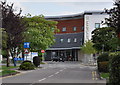
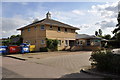
The new Epping Forest Unit, St. Margarets Hospital.
This new unit houses various clinics and the Cafe.
Image: © Lynda Poulter
Taken: 2 Aug 2009
0.12 miles
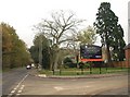
2
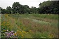
Pond Near Aragon Mews
The pink flowers are Common Mallow. I think the yellow ones are St John's Wort.
Image: © Glyn Baker
Taken: 28 Jul 2016
0.13 miles
3
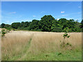
Edge of Epping Lower Forest
The near field is described on the City of London Epping Forest Map as "City owned Buffer Land with access on public or permissive rights of way".
Image: © Robin Webster
Taken: 17 Aug 2015
0.13 miles
5
The Limes Medical Centre and Co-op Pharmacy.
The medical centre and pharmacy are brightened up here by the display of brightly coloured wheelie bins.
Image: © Lynda Poulter
Taken: 2 Aug 2009
0.13 miles
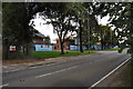
7
The Plain, Epping
The junction of the B181 with Kingswood Park, a new housing development partly built on the site of redundant buildings associated with nearby St Margaret's Hospital. On the left, the B road heads through Lower Forest towards North Weald Bassett.
Image: © Derek Harper
Taken: 17 Nov 2010
0.14 miles
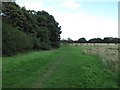
8
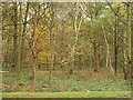
Lower Forest
On Epping Plain; dense deciduous woodland seen across the B181 near Kings Wood Park.
Image: © Derek Harper
Taken: 17 Nov 2010
0.14 miles
9
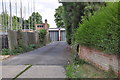
Entrance to the Ambulance Station.
The poles on the left are part of the new houses being built on land at the back of the hospital.
Image: © Lynda Poulter
Taken: 2 Aug 2009
0.14 miles
10
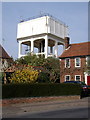
Fairfield Road Reservoir Water Tower
The water Tower on the opposite side of the road to the reservoir.
Image: © Lynda Poulter
Taken: 13 Apr 2007
0.15 miles