IMAGES TAKEN NEAR TO
The Briars, Ongar Road, BRENTWOOD, CM15 0DD
Introduction
This page details the photographs taken nearby to The Briars, Ongar Road, CM15 0DD by members of the Geograph project.
The Geograph project started in 2005 with the aim of publishing, organising and preserving representative images for every square kilometre of Great Britain, Ireland and the Isle of Man.

There are currently over 7.5m images from over14,400 individuals and you can help contribute to the project by visiting https://www.geograph.org.uk
Image Map
Images are licensed for reuse under creativecommons.org/licenses/by-sa/2.0
Notes
- Clicking on the map will re-center to the selected point.
- The higher the marker number, the further away the image location is from the centre of the postcode.
Image Listing (14 Images Found)
Images are licensed for reuse under creativecommons.org/licenses/by-sa/2.0
Image
Details
Distance
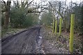
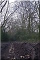
3
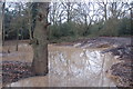
Doddinghurst Common between Cow Farm Lane and the Ongar Road
Between the lane and the footpath to the Ongar Road the wooded area has been extensively damaged by 4x4's. Very deep hollows and ruts have been made which have flooded. Most of the undergrowth has been destroyed and many of the trees damaged.
Image: © Hugh Gorton
Taken: 6 Jan 2015
0.15 miles
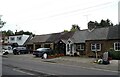
5
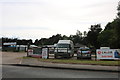
Time 4 Pets on Ongar Road, Kelvedon Hatch
Image: © David Howard
Taken: 25 May 2019
0.17 miles
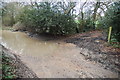
6
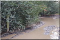
Footpath from Cow Farm Lane to the Ongar Road
This is about 20m down the 'path' from the lane. The path has been completely wrecked by 4x4 drivers who have created huge ruts and depressions which are currently flooded. At least they haven't demolished the Public Footpath sign yet.
Image: © Hugh Gorton
Taken: 6 Jan 2015
0.18 miles
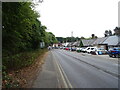
7
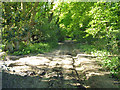
Byway to Fox Hatch
A well surfaced track at first, but not so good on this section along the eastern margin of the wooded Doddinghurst Common.
Image: © Robin Webster
Taken: 26 May 2012
0.19 miles
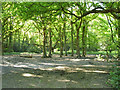
8
Crow Farm Lane and Doddinghurst Common
The wood to the left of Image is Doddinghurst Common.
Image: © Glyn Baker
Taken: 4 Mar 2013
0.19 miles
9
Crow Farm lane
The 4 x 4 mud pluggers clearly enjoy carving deep ruts in the byway and on Doddinghust common too.
Image: © Glyn Baker
Taken: 4 Mar 2013
0.19 miles
10
Cow Farm Lane - junction with footpath to Ongar Road
This at the south end of the wooded area where the public footpath to the Ongar Road joins the lane. Note the damage caused by off-roaders including the flooded depression on the left, and the 4x4 tyre tracks and ruts at the start of the footpath.
Image: © Hugh Gorton
Taken: 6 Jan 2015
0.19 miles