IMAGES TAKEN NEAR TO
Chester Road, NESTON, CH64 9UA
Introduction
This page details the photographs taken nearby to Chester Road, CH64 9UA by members of the Geograph project.
The Geograph project started in 2005 with the aim of publishing, organising and preserving representative images for every square kilometre of Great Britain, Ireland and the Isle of Man.

There are currently over 7.5m images from over14,400 individuals and you can help contribute to the project by visiting https://www.geograph.org.uk
Image Map
Images are licensed for reuse under creativecommons.org/licenses/by-sa/2.0
Notes
- Clicking on the map will re-center to the selected point.
- The higher the marker number, the further away the image location is from the centre of the postcode.
Image Listing (154 Images Found)
Images are licensed for reuse under creativecommons.org/licenses/by-sa/2.0
Image
Details
Distance
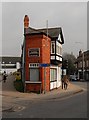
1
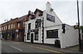
The Royal Arcade, Chester Road, Neston
Unit One in the Royal Arcade is home to Linda's Hairdressers.
Image: © John S Turner
Taken: 14 Feb 2011
0.01 miles
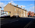
3
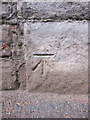
Bench mark on Chester Road bridge
This bench mark is on the north west side of the Chester Road railway bridge abutment. It seems to be a modern mark first shown clearly on the 1968 O.S. map, and possibly on the smaller scale 1954 map. See also Image An earlier mark was recorded on the south east side of the bridge, but that now seems to be lost.
Image: © John S Turner
Taken: 14 Feb 2011
0.02 miles
4
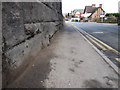
Chester Road and a bench mark
Looking along Chester Road from underneath the railway bridge. There is a bench mark on the left Image
Image: © John S Turner
Taken: 14 Feb 2011
0.02 miles
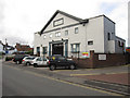
6
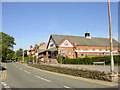
Neston Civic Hall
Neston Civic Hall on Hinderton Road.
Image: © Sue Adair
Taken: 3 Jun 2006
0.06 miles
7
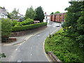
Bridge Street, Neston
Looking north from the footbridge which carries the Wirral Way.
Image: © Oliver Dixon
Taken: 4 Jun 2014
0.07 miles
8
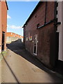
Pykes Weint, Neston
An area of modern housing set back from the east side of High Street. https://www.geograph.org.uk/photo/5681239 to the Pykes Weint name sign.
Image: © Jaggery
Taken: 15 Feb 2018
0.07 miles
9
Brook Street towards Sainsbury's, Neston
A bicentenary mural https://www.geograph.org.uk/photo/5680830 is on the left.
Image: © Jaggery
Taken: 15 Feb 2018
0.08 miles
10
Former Barclays Bank branch, High Street, Neston
Viewed from St Mary & St Helen's churchyard in February 2018.
Barclays was the last remaining bank branch in Neston. It closed down in October 2017.
The former NatWest bank branch in Neston is now the Elephant Bank pizzeria and bar. https://www.geograph.org.uk/photo/5681203
Image: © Jaggery
Taken: 15 Feb 2018
0.08 miles