1
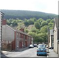
Looking SW from the edge of Trehafod railway station
In the foreground is Trehafod Road and, next to the red car, houses in Bethel Court. The building in the middle distance is Hafod Primary School. http://www.geograph.org.uk/photo/2397518
Image: © Jaggery
Taken: 6 May 2011
0.01 miles
2
Bethesda Street, Trehafod
Houses on the SE side of the street, viewed from near the former Bethesda chapel, http://www.geograph.org.uk/photo/2397459 now flats.
At the end of the street is a flood defence wall http://www.geograph.org.uk/photo/2397500 http://www.geograph.org.uk/photo/2397505 along the north bank of the River Rhondda.
Image: © Jaggery
Taken: 6 May 2011
0.07 miles
3
Flood defence wall (2), Trehafod
There were damaging floods from the River Rhondda in Trehafod on several occasions in the twentieth century. The most serious and widespread flood was in 1960, when one man died.
In the late 1990s, a flood defence wall was built along the north bank of the Rhondda in Trehafod. This section is along Lewis Street, viewed from the corner of Bethesda Street.
http://www.geograph.org.uk/photo/2397500 to a view of the wall in the opposite direction.
Image: © Jaggery
Taken: 6 May 2011
0.07 miles
4
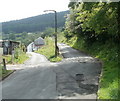
Roads to Ael-y-bryn and Pleasant View, Trehafod
The road on the right heads towards Pleasant View houses, about 200 metres away.
The road on the left heads for a row of six houses on a street named Ael-y-bryn.
Trehafod Road is about 30 metres behind the camera.
Image: © Jaggery
Taken: 6 May 2011
0.09 miles
5
Trehafod and the Rhondda River
Image: © Gareth James
Taken: 4 Apr 2015
0.09 miles
6
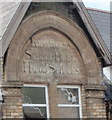
Inscription on Hafod Primary School, Trehafod
The inscription on the school http://www.geograph.org.uk/photo/2397518 shows
LLANWONNO
SCHOOL BOARD
HAFOD SCHOOLS
I was surprised that Llanwonno (also spelt Llanwynno) once had a school board, as it is a tiny hamlet
Image consisting of one church and one pub, (and no houses!) in St Gwynno Forest. The explanation is that the ancient parish of Llanwonno was centred at the church, but covered a wide area of the Rhondda, including Porth, Abercynon and parts of Mountain Ash and Pontypridd.
Image: © Jaggery
Taken: 6 May 2011
0.10 miles
7
Hafod Primary School, Trehafod
Located on Wayne Street. The school's playground borders the north bank of the River Rhondda.
Image: © Jaggery
Taken: 6 May 2011
0.10 miles
8
River Rhondda downstream from Lower Eirw Bridge
The view south from the Grade II listed bridge. http://www.geograph.org.uk/photo/2428814
http://www.geograph.org.uk/photo/2428856 to the view upstream.
Image: © Jaggery
Taken: 6 May 2011
0.13 miles
9
Basic urinal at the western edge of Lower Eirw Bridge, Trehafod
A urinal with no other facilities is at the western edge of the Grade II listed bridge. http://www.geograph.org.uk/photo/2428814
There are no pedestals or wash basins, but at least the facility is always open!
A sign on the wall warns CAUTION FLOORS MAY BE SLIPPERY.
Image: © Jaggery
Taken: 6 May 2011
0.13 miles
10
Plaque on Lower Eirw Bridge, Trehafod
The plaque is on this bridge http://www.geograph.org.uk/photo/2428814 over the River Rhondda.
Image: © Jaggery
Taken: 6 May 2011
0.13 miles


