1
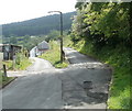
Roads to Ael-y-bryn and Pleasant View, Trehafod
The road on the right heads towards Pleasant View houses, about 200 metres away.
The road on the left heads for a row of six houses on a street named Ael-y-bryn.
Trehafod Road is about 30 metres behind the camera.
Image: © Jaggery
Taken: 6 May 2011
0.05 miles
2
Entrance to Rhondda Heritage Park, Trehafod
Viewed across Coedcae Road. The park is on the site of the former Lewis Merthyr colliery.
Image: © Jaggery
Taken: 6 May 2011
0.09 miles
3
Grade II listed Lower Eirw Bridge, Trehafod
The bridge carries Trehafod Road over the River Rhondda. A plaque http://www.geograph.org.uk/photo/2428818 on the bridge records that the bridge was widened in 1907 and reconstructed (in the form seen here) in 1927. The bridge was made by the Horsehay Company Ltd of Horsehay,
Image Shropshire.
The bridge was Grade II listed in 1996.
The large building on the far side of the bridge is The Bertie. http://www.geograph.org.uk/photo/2428647
Image: © Jaggery
Taken: 6 May 2011
0.10 miles
4
The Bertie, Trehafod
Pub, hotel and restaurant located on the corner of Phillips Terrace and Cadwgan Terrace, on the west bank of the River Rhondda.
Bertie was the name of a shaft sunk in 1880 at the nearby Lewis Merthyr Colliery, now Rhondda Heritage Park. It was named after one of the sons of the colliery owner (William Thomas Lewis, Lord Merthyr).
Image: © Jaggery
Taken: 6 May 2011
0.10 miles
5
Looking SW from the edge of Trehafod railway station
In the foreground is Trehafod Road and, next to the red car, houses in Bethel Court. The building in the middle distance is Hafod Primary School. http://www.geograph.org.uk/photo/2397518
Image: © Jaggery
Taken: 6 May 2011
0.11 miles
6
Recently-built house, Bryn Eirw, Trehafod
The house is near the Coedcae Road junction and the entrance http://www.geograph.org.uk/photo/2430575 to Rhondda Heritage Park.
In the distance are older terrace houses.
Image: © Jaggery
Taken: 6 May 2011
0.12 miles
7
Coedcae Road, Trehafod
The view past houses on the north side of the road, looking towards Rhondda Heritage Park.
Image: © Jaggery
Taken: 6 May 2011
0.12 miles
8
Cycle route 881 signpost at the western end of Lower Eirw Bridge, Trehafod
At the western edge of the separate footpath http://www.geograph.org.uk/photo/2428838 across the River Rhondda, National Cycle Network route 881 signs point left for Pontypridd, Rhydyfelin and Abercynon, right for Porth and Rhondda Heritage Park.
Image: © Jaggery
Taken: 6 May 2011
0.14 miles
9
Plaque on Lower Eirw Bridge, Trehafod
The plaque is on this bridge http://www.geograph.org.uk/photo/2428814 over the River Rhondda.
Image: © Jaggery
Taken: 6 May 2011
0.14 miles
10
Two bridges, Bridge Street, Trehafod
Viewed from the edge of Trehafod Road. The nearer bridge carries the A4058 over the River Rhondda, visible on the left. Behind it, just visible along the roadway, is the darker grey of the bridge carrying the Rhondda Line railway track.
On the left, behind the two bridges, is a wide-bore pipe bridge. http://www.geograph.org.uk/photo/2428589
Image: © Jaggery
Taken: 6 May 2011
0.14 miles


