IMAGES TAKEN NEAR TO
Sycamore Close, BRIDGEND, CF31 1QS
Introduction
This page details the photographs taken nearby to Sycamore Close, CF31 1QS by members of the Geograph project.
The Geograph project started in 2005 with the aim of publishing, organising and preserving representative images for every square kilometre of Great Britain, Ireland and the Isle of Man.

There are currently over 7.5m images from over14,400 individuals and you can help contribute to the project by visiting https://www.geograph.org.uk
Image Map
Images are licensed for reuse under creativecommons.org/licenses/by-sa/2.0
Notes
- Clicking on the map will re-center to the selected point.
- The higher the marker number, the further away the image location is from the centre of the postcode.
Image Listing (11 Images Found)
Images are licensed for reuse under creativecommons.org/licenses/by-sa/2.0
Image
Details
Distance
1
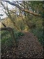
Public footpath in woodland to the west of Litchard
This path branches off from National Cycle Network Route 885 at the northern edge of Bridgend. At that point it is narrow, lacking in signage and has all the appearance of a very minor path. (It can be seen at its junction with the cycle path in Image] through the wooden fencing in the right half of the image.) The path broadens further along, and turns out to offer a pleasant woodland walk.
Image: © eswales
Taken: 1 Nov 2022
0.10 miles
2
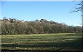
Woodland below Litchard
Viewed across a river meadow from Route 885 of the National Cycle Network, part of a strip of woodland which runs along the bottom and lower slopes of a hillside nearly a kilometre long. The more northerly parts of Litchard in Bridgend lie at the top of the hillside, along with an area of open ground to the north of them.
Most, if not all, of that part of the strip of woodland which is seen in the photo is classed as Ancient Semi-Natural Woodland in the Ancient Woodland Inventory for Wales. Other parts, out of picture to the north, however, do not qualify as ancient woodland.
Image: © eswales
Taken: 16 Jan 2023
0.12 miles
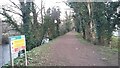
3
National Cycle Network Route 885 leaving Bridgend
The cycle route here is at the end of its passage past housing in Bridgend and about to run beside a river meadow as it makes its way northwards towards Sarn. Apart from leaving built-up Bridgend, the route here leaves behind the road network, having passed along or beside roads for the great part of its northward passage from the centre of Bridgend up to this point. It rejoins the road network at points further north.
Image: © eswales
Taken: 1 Nov 2022
0.13 miles
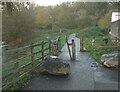
5
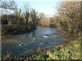
A bend in the River Ogmore at the western edge of Bridgend
A view from Route 885 of the National Cycle Network at the point where, for those travelling northwards, it leaves residential Bridgend to pass alongside river meadows – just as the river does here.
Image: © eswales
Taken: 16 Jan 2023
0.14 miles

7
Glanrhyd
Riverside footpath walk from Glanrhyd to Bridgend
Image: © Colin Prosser
Taken: 28 Feb 2021
0.23 miles
8
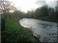
The River Ogmore at the western edge of Bridgend
A view downstream from a spot beside National Cycle Route 885 just as it reaches the fringes of the town from the north. The stretch of the river seen in the image lies immediately downstream of the one seen in Image
Image: © eswales
Taken: 1 Nov 2022
0.23 miles
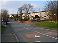
9

Bridgend : Coity Road B4181
Looking along Coity Road as it heads into Bridgend.
Image: © Lewis Clarke
Taken: 24 Aug 2014
0.24 miles
10

Ordnance Survey Cut Mark
This OS cut mark can be found on the wall south of the entrance to The Parc. It marks a point 65.536m above mean sea level.
Image: © Adrian Dust
Taken: 26 May 2018
0.24 miles