IMAGES TAKEN NEAR TO
Caribou Way, CAMBRIDGE, CB1 9XG
Introduction
This page details the photographs taken nearby to Caribou Way, CB1 9XG by members of the Geograph project.
The Geograph project started in 2005 with the aim of publishing, organising and preserving representative images for every square kilometre of Great Britain, Ireland and the Isle of Man.

There are currently over 7.5m images from over14,400 individuals and you can help contribute to the project by visiting https://www.geograph.org.uk
Image Map
Images are licensed for reuse under creativecommons.org/licenses/by-sa/2.0
Notes
- Clicking on the map will re-center to the selected point.
- The higher the marker number, the further away the image location is from the centre of the postcode.
Image Listing (49 Images Found)
Images are licensed for reuse under creativecommons.org/licenses/by-sa/2.0
Image
Details
Distance
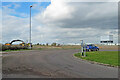
1
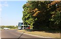
Cherry Hinton Road at the junction of Gazelle Way
The junction is the end of Cambridge, the countryside is opposite the road.
Image: © David Howard
Taken: 9 Aug 2020
0.05 miles
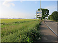
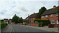
2
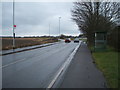
Cherry Hinton Road
Heading north east towards Teversham.
Image: © JThomas
Taken: 5 Mar 2016
0.06 miles
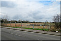
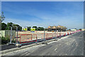
3
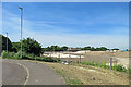
Cherry Hinton: Trinity Fields taking shape
Trinity Fields is a housing development at the northern end of Cherry Hinton, on the edge of the airport. A settling pond has been formed in the centre of the picture and the first houses are taking shape in the distance. Image], taken a minute earlier, shows them more clearly.
Image: © John Sutton
Taken: 16 Jun 2022
0.06 miles
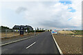
4
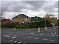
Eland Way
A turning off Gazelle Way, and the ruminant theme is continued into the side roads Caribou Way, Impala Drive and Antelope Way.
Image: © Keith Edkins
Taken: 11 Nov 2007
0.07 miles
5
Cherry Hinton: soon to be houses
Trinity Fields is a housing development on the northern edge of Cherry Hinton, next to the airport (whose buildings show on the low skyline). The lamp standard replaces the one shown in Image], taken in 2010.
Image: © John Sutton
Taken: 13 Mar 2022
0.07 miles
6
Teversham Drift
On the edge of Cherry Hinton.
Image: © Hugh Venables
Taken: 20 Jun 2014
0.08 miles
7
Cherry Hinton: the beginnings of Trinity Fields
Trinity Fields is to be a housing development on the northern edge of Cherry Hinton. Image] shows the site being cleared in February 2021.
Image: © John Sutton
Taken: 13 Mar 2022
0.09 miles
8
Cherry Hinton: progress at Trinity Fields
A new estate is being built on land next to the airport on the northern edge of Cherry Hinton. For comparison, see Image] (June 2022).
Image: © John Sutton
Taken: 10 Sep 2022
0.09 miles
9
Eland Way, Cherry Hinton
Housing in this large dormitary village to the east of Cambridge.
Image: © Jonathan Billinger
Taken: 8 Jul 2008
0.09 miles
10
Cherry Hinton: the first houses at Trinity Fields
Trinity Fields is a housing development at the northern end of Cherry Hinton, on a large site at the edge of the airport. Image] (February 2022) shows an early stage of the work.
Image: © John Sutton
Taken: 16 Jun 2022
0.10 miles