IMAGES TAKEN NEAR TO
Portinscale, KESWICK, CA12 5RD
Introduction
This page details the photographs taken nearby to CA12 5RD by members of the Geograph project.
The Geograph project started in 2005 with the aim of publishing, organising and preserving representative images for every square kilometre of Great Britain, Ireland and the Isle of Man.

There are currently over 7.5m images from over14,400 individuals and you can help contribute to the project by visiting https://www.geograph.org.uk
Image Map
Images are licensed for reuse under creativecommons.org/licenses/by-sa/2.0
Notes
- Clicking on the map will re-center to the selected point.
- The higher the marker number, the further away the image location is from the centre of the postcode.
Image Listing (108 Images Found)
Images are licensed for reuse under creativecommons.org/licenses/by-sa/2.0
Image
Details
Distance
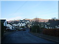
1
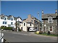
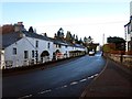
Portinscale
The centre of Portinscale. A popular tourist attraction, Portinscale is the only village in the United Kingdom named after a prostitute. The etymology of the name means ‘house of the harlot’.
The Cumbria Way turns right here between the buildings, following the old A594 road towards Long Bridge and Keswick (next photograph Image).
Image: © Adrian Taylor
Taken: 18 Apr 2015
0.00 miles
2
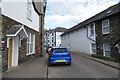
Letterbox in Portinscale
The road leads to the footbridge over the River Derwent.
Image: © DS Pugh
Taken: 31 Mar 2024
0.01 miles
3
Portinscale
The village of Portinscale.
Image: © Philip Halling
Taken: 6 Apr 2009
0.01 miles
4
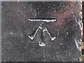
Benchmark, Derwentwater Hotel, Portinscale
Detail of an Ordnance Survey cut benchmark on a painted stone quoin on the south west corner of the Derwent Hotel.
The benchmark marks a height of 83.4814m above Ordnance Datum Newlyn last levelled and verified in 1954 (location photograph Image).
Image: © Adrian Taylor
Taken: 10 Aug 2016
0.02 miles
5

Corner of the Derwentwater Hotel
Detail of the south west corner of the Derwentwater Hotel. There is an Ordnance Survey cut benchmark on one of the painted stone quoins adjacent to the fire hydrant marker (detail photograph Image).
The Cumbria Way long distance trail from Ulverston to Carlisle follows the road beside the hotel, passing the benchmark.
Image: © Adrian Taylor
Taken: 10 Aug 2016
0.02 miles
6
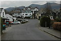
The road through Portinscale
Looking along the main road through Portinscale.
Image: © Graham Robson
Taken: 4 Nov 2013
0.02 miles
7
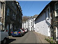
Portinscale
Portinscale is a small village close to the western shore of Derwent Water, within the Lake District National Park. It is approximately 1 mile (via footbridge and footpath) from Keswick.
Image: © David Dixon
Taken: 12 Apr 2014
0.02 miles
8
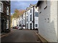
Old A594 road, Portinscale
This narrow street in Portinscale was formerly the A594 road linking west Cumberland with Penrith and the A6. Portinscale was bypassed and the A594 renumbered to become part of the A66 between Penrith and Cockermouth.
The road is the route of The Cumbria Way long distance footpath (next photograph Image).
The black and white building in the background is the Derwentwater Hotel; there is an Ordnance Survey cut benchmark on the near corner (photograph Image).
Image: © Adrian Taylor
Taken: 18 Apr 2015
0.02 miles
9
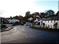
Early morning in Portinscale
Looking along the main road through the small village of Portinscale.
Image: © Graham Robson
Taken: 4 Nov 2013
0.02 miles
10
Portinscale
The place name description may raise a few eyebrows locally. 'The hut of the harlots'. 'Porqeneschal 1160'(whaley 2006).
Image: © Michael Graham
Taken: 4 Jan 2009
0.03 miles