IMAGES TAKEN NEAR TO
Mill Street, COLERAINE, BT52 1PB
Introduction
This page details the photographs taken nearby to Mill Street, BT52 1PB by members of the Geograph project.
The Geograph project started in 2005 with the aim of publishing, organising and preserving representative images for every square kilometre of Great Britain, Ireland and the Isle of Man.

There are currently over 7.5m images from over14,400 individuals and you can help contribute to the project by visiting https://www.geograph.org.uk
Image Map
Images are licensed for reuse under creativecommons.org/licenses/by-sa/2.0
Notes
- Clicking on the map will re-center to the selected point.
- The higher the marker number, the further away the image location is from the centre of the postcode.
Image Listing (298 Images Found)
Images are licensed for reuse under creativecommons.org/licenses/by-sa/2.0
Image
Details
Distance
1
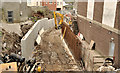
The Lodge Burn, Coleraine (2)
See Image (January 2012). A similar view, from the Railway Road, where work is continuing on this flood-alleviation scheme. The retaining wall (left) has been built since the previous photograph. Continue to Image – 4 April 2012.
Image: © Albert Bridge
Taken: 24 Mar 2012
0.01 miles
2
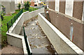
The Lodge Burn, Coleraine (6)
See Image (January 2012), Image (March 2012) and Image (April 2012). Work on this part of the scheme, between the Railway Road and Brook Street (Long Commons on the Google map), now seems to be complete. Continue to Image (3 August 2012).
Image: © Albert Bridge
Taken: 29 Jun 2012
0.01 miles
3
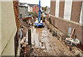
The Lodge Burn, Coleraine
The Lodge Burn, a short watercourse flowing through Coleraine into the Bann, is prone to flooding Image A major flood alleviation scheme is now underway. This view is downstream from the Railway Road bridge where the burn has been temporarily diverted. When complete this section will become “a rock ramp pool and weir fish pass”. Continue to Image (March 2012).
Image: © Albert Bridge
Taken: 11 Jan 2012
0.01 miles
4
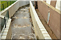
The Lodge Burn, Coleraine (10)
See Image The Lodge Burn, looking downstream, from the Railway Road. It seemed to be coping with the recent rain. This is how it looked during rebuilding in January 2012 Image
Image: © Albert Bridge
Taken: 31 Oct 2012
0.01 miles
5
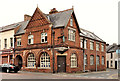
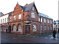
The "Chronicle" office, Coleraine
A building, at the corner of the Railway Road and Mill Street Image (right) housing the offices of the “Coleraine Chronicle”. Founded in 1844, the paper is no longer locally owned.
Image: © Albert Bridge
Taken: 24 Mar 2012
0.02 miles
6
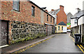
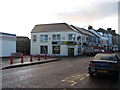
Mill Street, Coleraine (1)
A narrow street running from the Railway Road to Brook Street and the Long Commons (background). Temporarily closed to through traffic during major work on the Lodge Burn Image Image shows the hoist (middle top).
Image: © Albert Bridge
Taken: 11 Jan 2012
0.02 miles
7
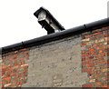
Mill Street, Coleraine (2)
The remains of a hoist and pulley – seen at middle top in Image
Image: © Albert Bridge
Taken: 11 Jan 2012
0.02 miles
8
Lodge Burn re-direction
This is part of the Lodge Burn flood alleviation scheme. The new culvert runs under Railway Road into Anderson Park.
Image: © Willie Duffin
Taken: 11 Apr 2012
0.02 miles
9
Coleraine Chronicle office
At the junction of Railway Road and Mill Street. A long established local newspaper office.
Image: © Willie Duffin
Taken: 8 Jan 2014
0.02 miles
10
Subway Coleraine
Situated on Railway road.
Image: © Willie Duffin
Taken: 8 Jan 2014
0.03 miles