IMAGES TAKEN NEAR TO
Old Shore Court, CARRICKFERGUS, BT38 8WN
Introduction
This page details the photographs taken nearby to Old Shore Court, BT38 8WN by members of the Geograph project.
The Geograph project started in 2005 with the aim of publishing, organising and preserving representative images for every square kilometre of Great Britain, Ireland and the Isle of Man.

There are currently over 7.5m images from over14,400 individuals and you can help contribute to the project by visiting https://www.geograph.org.uk
Image Map
Images are licensed for reuse under creativecommons.org/licenses/by-sa/2.0
Notes
- Clicking on the map will re-center to the selected point.
- The higher the marker number, the further away the image location is from the centre of the postcode.
Image Listing (15 Images Found)
Images are licensed for reuse under creativecommons.org/licenses/by-sa/2.0
Image
Details
Distance
1
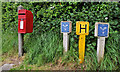
Letter box near Carrickfergus
Post-mounted EIIR letter box, on the Old Shore Road, sharing the limelight with some fire-hydrant posts. Image shows the replacement.
Image: © Albert Bridge
Taken: 7 May 2011
0.05 miles
2
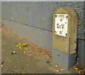
Larne Rural District Council fire hydrant post, Trooperslane, Carrickfergus
A post marking a section control valve, on the Trooperslane Road, near the Old Shore Road – a survivor from before the reorganisation of local government in 1973. The initials “LRDC” mean “Larne Rural District Council” which administered a wider area than just the immediate environs of Larne town. See also Image
Image: © Albert Bridge
Taken: 22 Apr 2014
0.05 miles
3
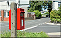
Postbox BT38 352D, Trooperslane, Carrickfergus (June 2017)
Post-mounted pressed-steel postbox (BT38 352D) at the corner of the Trooperslane and Old Shore Roads. It replaced this one Image
Image: © Albert Bridge
Taken: 17 Jun 2017
0.06 miles
4
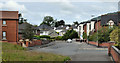
The Old Shore Road, Trooperslane, Carrickfergus
Part of the Shore Road long-since replaced by a dual carriageway Image on the seaward side. Most of the houses post-date the dual carriageway.
Image: © Albert Bridge
Taken: 1 Jul 2011
0.09 miles
5
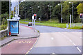
Bus Stop on Belfast Road between Carrickfergus and Greenisland
Image: © David Dixon
Taken: 28 Sep 2017
0.10 miles
6
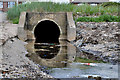
Culvert, Trooperslane, Carrickfergus
A culvert under this road Image It carries a stream which rises near Dorisland reservoir and flows into Belfast Lough.
Image: © Albert Bridge
Taken: 1 Jul 2011
0.10 miles
7
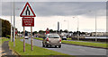
"End of dual carriageway" sign, Trooperslane, Carrickfergus
The “end of dual carriageway” sign at the end of this short stretch (about a mile) of dual carriageway on the Belfast – Carrickfergus road. It continues as a four-lane road as far as Downshire.
Image: © Albert Bridge
Taken: 1 Jul 2011
0.16 miles
8
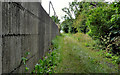
Lane, Carrickfergus
The Belfast Road end of a lane which formerly led to and through part of the old Courtaulds factory Image (behind the wall on the left). I might be wrong but I think that it eventually led to the railway close to Mount station. The station was built to serve employees of the factory and did not have any public access.
Image: © Albert Bridge
Taken: 1 Jul 2011
0.18 miles
9
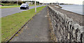
The seawall near Carrickfergus (1)
Part of the seawall, on the Belfast side of the Sloefield Road. Now some 40 years old and well plastered, there are no cracks to allow the accumulation of wind-blown soil and no wildflowers.
Image: © Albert Bridge
Taken: 1 Jul 2011
0.20 miles
10
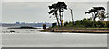
Seapark, Carrickfergus
Seapark lies between Carrickfergus and Greenisland. The Green Island Image is at middle left. The trees (right) hide a waste-water treatment works.
Image: © Albert Bridge
Taken: 1 Jul 2011
0.22 miles