IMAGES TAKEN NEAR TO
Old Dundonald Road, BELFAST, BT16 2EG
Introduction
This page details the photographs taken nearby to Old Dundonald Road, BT16 2EG by members of the Geograph project.
The Geograph project started in 2005 with the aim of publishing, organising and preserving representative images for every square kilometre of Great Britain, Ireland and the Isle of Man.

There are currently over 7.5m images from over14,400 individuals and you can help contribute to the project by visiting https://www.geograph.org.uk
Image Map
Images are licensed for reuse under creativecommons.org/licenses/by-sa/2.0
Notes
- Clicking on the map will re-center to the selected point.
- The higher the marker number, the further away the image location is from the centre of the postcode.
Image Listing (38 Images Found)
Images are licensed for reuse under creativecommons.org/licenses/by-sa/2.0
Image
Details
Distance
1
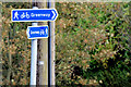
Comber Greenway cycle route signs, Dundonald (October 2014)
Comber Greenway cycle route signs, on the Comber Road, close to the Grahamsbridge Road. The Greenway is part of National Cycle Network route no 99 Image and Image
Image: © Albert Bridge
Taken: 6 Oct 2014
0.08 miles
2
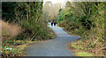
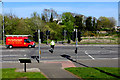
The Comber Greenway, Dundonald
The Comber Greenway Image (looking towards Knock), to the west of the entrance from the Comber Road, Dundonald. The conversion of the disused railway has proved to be a popular amenity. Continue to Image
Image: © Albert Bridge
Taken: 23 Jan 2010
0.09 miles
3
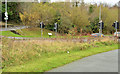
Dundonald railway station (site of) (2)
See Image The site of the station is marked by the trees but the “old railway” effect is not so obvious. The photograph was taken from the Comber Greenway, on what was the trackbed, where the line crossed the Comber Road (middle) by an underbridge. For the record, part of the Greenway (right) is new and doesn’t quite follow the course of the line.
Image: © Albert Bridge
Taken: 9 Dec 2013
0.09 miles
4
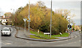
Dundonald railway station (site of) (1)
Dundonald station was on an embankment at the apex of the Old Dundonald Road (left) and the Comber Road. The station has gone but the trackbed is now part of the Comber Greenway Image – marked by the conspicuous clump of trees. This view is towards Knock station Image and Queen’s Quay Image The Comber Road (foreground) was crossed by an underbridge. Image shows a similar view from the Greenway.
Image: © Albert Bridge
Taken: 9 Dec 2013
0.09 miles
5
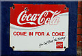
Old Coca-Cola sign, Dundonald
Old enamel Coca-Cola sign, on premises on the Comber Road.
Image: © Albert Bridge
Taken: 23 Jan 2010
0.09 miles
6
Comber Greenway
The crossing which takes the greenway across the busy Comber Road. The railway crossed the road at this point on a bridge of which there's no trace remaining that I could see.
Image: © Robert Ashby
Taken: 22 Apr 2015
0.10 miles
7
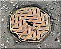
Octagonal access cover, Dundonald
A small octagonal access cover on the Grahamsbridge Road, opposite Millar’s Lane. No maker's name or purpose shown just “HCB 44”. Further information welcome.
Image: © Albert Bridge
Taken: 6 Oct 2014
0.10 miles
8
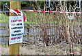
Japanese knotweed eradication, Dundonald (October 2014)
An attempt, at the Comber Road end of the Comber Greenway, to eradicate the alien and invasive Japanese knotweed http://www.habitas.org.uk/flora/species.asp?item=3762.
Image: © Albert Bridge
Taken: 6 Oct 2014
0.10 miles
9
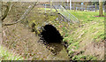
Graham's Bridge, Dundonald
The present Graham’s Bridge, carrying the Grahamsbridge Road Image across the Enler, is little more than a culvert. This view is downstream after which the river reaches another bridge at Millmount Image
Image: © Albert Bridge
Taken: 6 Mar 2014
0.11 miles
10
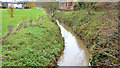
The Enler River, Dundonald (4)
The Enler, looking upstream towards the confluence Image, at Graham’s Bridge.
Image: © Albert Bridge
Taken: 22 Nov 2012
0.11 miles