IMAGES TAKEN NEAR TO
Karrington Heights, BELFAST, BT16 1XZ
Introduction
This page details the photographs taken nearby to Karrington Heights, BT16 1XZ by members of the Geograph project.
The Geograph project started in 2005 with the aim of publishing, organising and preserving representative images for every square kilometre of Great Britain, Ireland and the Isle of Man.

There are currently over 7.5m images from over14,400 individuals and you can help contribute to the project by visiting https://www.geograph.org.uk
Image Map
Images are licensed for reuse under creativecommons.org/licenses/by-sa/2.0
Notes
- Clicking on the map will re-center to the selected point.
- The higher the marker number, the further away the image location is from the centre of the postcode.
Image Listing (36 Images Found)
Images are licensed for reuse under creativecommons.org/licenses/by-sa/2.0
Image
Details
Distance
1
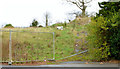
Vacant site, Dundonald
Part of a vacant site, on the north eastern side of the Comber Road Image, almost opposite the New Line.
Image: © Albert Bridge
Taken: 9 Dec 2013
0.09 miles
2
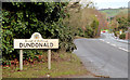
Welcome to Dundonald
A Castlereagh Borough Council sign on the Comber Road, on the inward side of the New Line. Castlereagh district will cease to exist after the reorganisation of local government. To quote from the Council’s website “In April 2015, as part of the reform of local government in Northern Ireland (previously known as the Review of Public Administration), the majority of households in Castlereagh will merge with Lisburn City Council with 38% of the population of Castlereagh and 21% of Lisburn moving to the new Belfast City Council.” My reading of the map is that the area on the left will be part of the Ballyhanwood ward and the right the Enler ward of the new Lisburn and Castlereagh district. The original “Castlereagh” was a barony http://en.wikipedia.org/wiki/Barony_(Ireland) – later divided into Castlereagh Upper and Lower. This link http://www.proni.gov.uk/index/local_history/geographical_index/baronies_.htm is to a map of the NI baronies. Their names survive for conveyancing and registration of title.
Image: © Albert Bridge
Taken: 9 Dec 2013
0.10 miles
3
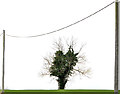
Cables and tree, Dundonald
Telegraph poles and a telephone cable, framing a lone tree, on a drumlin on the western side of the Comber Road.
Image: © Albert Bridge
Taken: 9 Dec 2013
0.12 miles
4
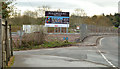
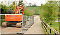
Millmount Village, Dundonald (1 in December 2013)
The view towards Comber at the corner of the Millmount Road. Work is underway in building the access roads and widening the Comber Road.
Image: © Albert Bridge
Taken: 9 Dec 2013
0.15 miles
5
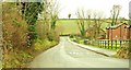
The Millmount Road, Dundonald (1)
The Millmount Road runs off the Comber Road (background) towards the main Belfast – Newtownards road. Back in 1963 the Matthew Plan envisaged a novelty which came to be known as the “Matthew Stop Line” ie a limit on the outward development of Belfast. It has not been taken too seriously. This photo shows the eastern limit of greater Belfast. Fields to the left and suburbs to the right. See also Image Image shows the road after stopping-up as part of the Millmount Village development.
Image: © Albert Bridge
Taken: 29 Jan 2009
0.16 miles
6
The Comber Greenway, Dundonald (October 2014)
A short stretch of the Comber Greenway, between the Grahamsbridge and Millmount Roads, where the course of the old railway no longer exists.
Image: © Albert Bridge
Taken: 6 Oct 2014
0.16 miles
7
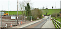
Millmount Village, Dundonald - March 2014(1)
The Millmount Road, looking towards the Comber Road, with the new Millmount Village road under construction on the left. It appears that the present line will become a cul-de-sac with access (lower left) from the new road.
Image: © Albert Bridge
Taken: 22 Mar 2014
0.17 miles
8
The Millmount Road, Dundonald - May 2014(1)
The Millmount Road Image (January 2009) is now the old line of the Millmount Road, stopped up at the Comber Road end, and used as an access from the new line (behind the hedge on the left) to Millmount Chase (out of picture to the right).
Image: © Albert Bridge
Taken: 5 May 2014
0.18 miles
9
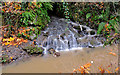
Drain, Dundonald
A culverted storm drain, flowing into the Enler, downstream from Graham’s Bridge Image The flow is greater than usual and the river muddier after heavy rain overnight.
Image: © Albert Bridge
Taken: 22 Nov 2012
0.18 miles
10
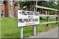
Millmount Road/Millmount Chase name signs, Dundonald (August 2015)
Combined name signs, showing the townland as Ballymaglaff, on the Millmount Road Image
Image: © Albert Bridge
Taken: 1 Aug 2015
0.19 miles