IMAGES TAKEN NEAR TO
Downsway, BRISTOL, BS39 7XL
Introduction
This page details the photographs taken nearby to Downsway, BS39 7XL by members of the Geograph project.
The Geograph project started in 2005 with the aim of publishing, organising and preserving representative images for every square kilometre of Great Britain, Ireland and the Isle of Man.

There are currently over 7.5m images from over14,400 individuals and you can help contribute to the project by visiting https://www.geograph.org.uk
Image Map (Loading...)


Getting Data...Please wait
Leaflet Map data © OpenStreetMap
Images are licensed for reuse under creativecommons.org/licenses/by-sa/2.0
Notes
- Clicking on the map will re-center to the selected point.
- The higher the marker number, the further away the image location is from the centre of the postcode.
Image Listing (22 Images Found)
Images are licensed for reuse under creativecommons.org/licenses/by-sa/2.0
Image
Details
Distance
1
Private lay-by
Nice to have a bit of private parking space.
Image: © Neil Owen
Taken: 11 Oct 2016
0.03 miles
2
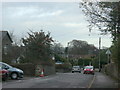
2009 : Farrington Road, Paulton
Heading into Paulton from Farrington Gurney.
The blue/grey structure in the background to the right is the training tower on the Clutton Rural District Fire Station. Image]
Image: © Maurice Pullin
Taken: 16 Nov 2009
0.06 miles
3
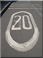
Dropped by ten
The large road signage has, like many others, has changed its mind. Twenty is plenty, apparently.
Image: © Neil Owen
Taken: 11 Oct 2016
0.07 miles
4
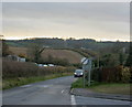
2009 : Paulton Road, Paulton
At the north west corner of the town heading to Farrington Gurney. Downsway leaves to the right.
The Mendip TV Transmitter Mast disappears into the clouds on the left. Image
Image: © Maurice Pullin
Taken: 16 Nov 2009
0.08 miles
5
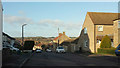
Carter Road, Paulton
From the junction with Park Road. The village in the distance is High Littleton.
Image: © Derek Harper
Taken: 9 Dec 2019
0.14 miles
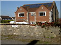
6
Rising Sun House
This odd house name might suggest it is a former public house, perhaps. But the building itself does not appear to be any older than post-WWII and, intriguingly enough, there was a pub just opposite called the Victoria Inn - itself not that old either. A new terrace on the site is named Victoria Place in its honour.
Image: © Neil Owen
Taken: 11 Oct 2016
0.16 miles
7
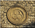
Plaque, Newtown Chapel, Paulton
The trefoil-centred plaque is on the gable end of the chapel shown in Image The words "Primitive Methodist" are clear enough, but the other word is badly eroded: "HA R" is discernable.
Image: © Derek Harper
Taken: 9 Dec 2019
0.17 miles
8
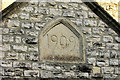
Datestone, Newtown Chapel, Paulton
"1909" appears to be the date of the schoolroom part of Image]; sources suggest the former Primitive Methodist Chapel itself was built earlier.
Image: © Derek Harper
Taken: 9 Dec 2019
0.17 miles
9
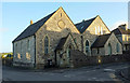
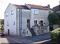
Newtown Chapel, Paulton
At the corner of Park Road (left) and Tennis Court Road. "The former Primitive Methodist Chapel" according to http://www.churches-uk-ireland.org/somerset.html ; it bears a date of 1909 on the right-hand gable, but that is perhaps when the schoolroom was added. The trefoil plaque has no discernable date. "Built of rockfaced squared coursed white lias rubble with oolitic limestone dressings, art nouveau cast iron gate to church" http://www.bathnes.gov.uk/sites/default/files/paulton_caa.pdf . Now converted into five flats.
Image: © Derek Harper
Taken: 9 Dec 2019
0.17 miles
10
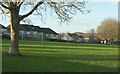
Paulton Memorial Park
Looking left from
Image: © Derek Harper
Taken: 9 Dec 2019
0.18 miles