IMAGES TAKEN NEAR TO
St. James Place, BRISTOL, BS16 9JA
Introduction
This page details the photographs taken nearby to St. James Place, BS16 9JA by members of the Geograph project.
The Geograph project started in 2005 with the aim of publishing, organising and preserving representative images for every square kilometre of Great Britain, Ireland and the Isle of Man.

There are currently over 7.5m images from over14,400 individuals and you can help contribute to the project by visiting https://www.geograph.org.uk
Image Map
Images are licensed for reuse under creativecommons.org/licenses/by-sa/2.0
Notes
- Clicking on the map will re-center to the selected point.
- The higher the marker number, the further away the image location is from the centre of the postcode.
Image Listing (52 Images Found)
Images are licensed for reuse under creativecommons.org/licenses/by-sa/2.0
Image
Details
Distance
1
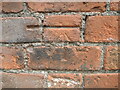
Benchmark on St James Place
A cutmark on a brick wall in Mangotsfield: see Image] for a wider view and https://www.bench-marks.org.uk/bm84841 for the entry in the Benchmark Database.
Image: © Neil Owen
Taken: 24 Jun 2021
0.02 miles
2
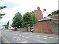
Along St James Place
Looking northwards to the ancient triangle at the heart of Mangotsfield. The old brick buildings were once associated with the vicarage of St James church. On the wall is a benchmark - see Image
Image: © Neil Owen
Taken: 24 Jun 2021
0.02 miles
3
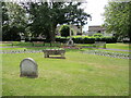
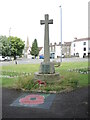
Mangotsfield remembers
A patch of greenery now exists directly south of the old triangle that was the historic part of Mangotsfield. The area was remodelled in the post-war period and some buildings cleared to provide the present space. The war memorial has been moved here, along with some flowers and other items. The rounded stone in the foreground bears tribute to a local councillor and chairman of the British Legion.
Image: © Neil Owen
Taken: 24 Jun 2021
0.03 miles
5
Remembering to remember
The war memorial has been treated to another form of more modern highlighting.
Image: © Neil Owen
Taken: 24 Jun 2021
0.04 miles
6
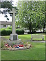
Mangotsfield war memorial
The memorial was erected by local voluntary contributions in 1919 and used to stand a little further north originally.
Image: © Neil Owen
Taken: 24 Jun 2021
0.04 miles
7
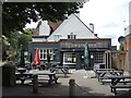
Outdoor tables at the Grapevine
A relatively new pub on the historic part of Mangotsfield.
Image: © Neil Owen
Taken: 24 Jun 2021
0.04 miles
8
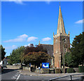
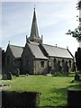
2011 : B4465 Mangotsfield Road, Mangotsfield
St. James Church is to the right.
"The former rural parish of Mangotsfield in south Gloucestershire, was anciently within Kingswood Chase, and originally comprised of what are now the north-east Bristol suburbs of Blackhorse, Bromley Heath, Downend, Emerson’s Green, Mangotsfield, Staple Hill, the eastern part of Oldbury Court and the upper part of Soundwell, and the two remaining rural hamlets of Bury Hill and Moorend. The whole parish, except the Oldbury Court part, remains outside the Bristol city boundary, and has some traces of its rural past.
The history of Mangotsfield stretches back to the Domesday Book of 1086 and almost certainly beyond. The name probably derives from Mangod’s Feld, Mangod being a Saxon word and Feld meaning a stretch of open country, in other words, Mangod’s stretch of open country. Mangotsfield village answers to most people’s idea of a “typical” English village, a nucleated settlement growing up around a medieval church with a manor house next door."
By Andrew Plaster
Published in B&AFHS Journal 125 September 2006
Image: © Maurice Pullin
Taken: 2 Sep 2011
0.04 miles
9
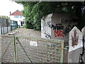
Sheltered sub-station
Sheltered by trees but not immune from visitors, this electricity sub-station dates from the post-war period.
Image: © Neil Owen
Taken: 24 Jun 2021
0.05 miles
10
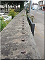
Gone for the effort?
The stumps of the iron railings remain in the walls of St James church. Presumably they were cut down and sent off for the war effort. Although some historians have cast doubt about the amount of railings, pots and pans that people donated to the factories, it seems reasonable to suggest that the church iron may have become a tank or battleship.
Image: © Neil Owen
Taken: 24 Jun 2021
0.05 miles