IMAGES TAKEN NEAR TO
Lupin Close, BRISTOL, BS16 7GN
Introduction
This page details the photographs taken nearby to Lupin Close, BS16 7GN by members of the Geograph project.
The Geograph project started in 2005 with the aim of publishing, organising and preserving representative images for every square kilometre of Great Britain, Ireland and the Isle of Man.

There are currently over 7.5m images from over14,400 individuals and you can help contribute to the project by visiting https://www.geograph.org.uk
Image Map
Images are licensed for reuse under creativecommons.org/licenses/by-sa/2.0
Notes
- Clicking on the map will re-center to the selected point.
- The higher the marker number, the further away the image location is from the centre of the postcode.
Image Listing (17 Images Found)
Images are licensed for reuse under creativecommons.org/licenses/by-sa/2.0
Image
Details
Distance
1
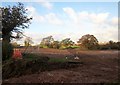
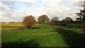
Development site by Howsmoor Lane
Preparations for residential development (part of Emersons Green East), seen from where a principal road will cross Howsmoor Lane. The trees are along a tributary of Folly Brook.
Image: © Derek Harper
Taken: 22 Nov 2013
0.07 miles
2
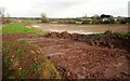
Entrance to development site, Howsmoor Lane
A reverse view of Image The Scania dumper is at work on a site where 81 houses are to be built.
Image: © Derek Harper
Taken: 22 Nov 2013
0.09 miles
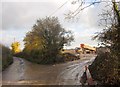
3
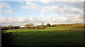
Howsmoor Lane
The lane approaches the site of Howsmoor Farm and the Bristol & Bath Science Park. On the left is the muddy entrance to a development site, parcel 8 of Emersons Green East.
Image: © Derek Harper
Taken: 22 Nov 2013
0.10 miles
4
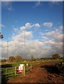
Masts, Howsmoor Lane
The Mangotsfield radio transmitter, due to be moved, possibly to near Frampton Cotterell, to make way for housing.
Image: © Derek Harper
Taken: 22 Nov 2013
0.11 miles
5
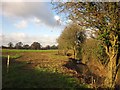
Farmland by Howsmoor Lane
I haven't been able to work out whether all this land by a tributary of the Folly Brook will be developed or not. A map dating from 2006 at http://www.southglos.gov.uk/Documents/PTE060184.pdf suggested not, but the neighbouring field - see Image] - is mapped in the same way. Development is under way across on the left, closer to the M4.
Image: © Derek Harper
Taken: 22 Nov 2013
0.12 miles
6
Development site by Howsmoor Lane
See Image], a view from the same spot. This looks to the right, with Whitehouse Farm. https://www.taylorwimpey.co.uk/proposed-developments/england/bristol/bristol/lyde-green-parcels-9-and-10 suggests that there will be semidetached houses here.
Image: © Derek Harper
Taken: 22 Nov 2013
0.13 miles
7
Land by Howsmoor Lane
From the same spot as Image], looking to the left. Beyond the radio transmitter mast (one of two that need to be moved to make way for housing) is a Sainsbury's distribution centre.
Image: © Derek Harper
Taken: 22 Nov 2013
0.15 miles
8
Tributary of the Folly Brook
Another view of the stream shown in Image], this time from the gate. Machinery is at work in the field, which will soon be built upon.
Image: © Derek Harper
Taken: 22 Nov 2013
0.16 miles
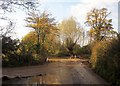
9
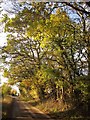
Howsmoor Lane
The stretch of lane that ran past the now demolished Hytoken House.
Image: © Derek Harper
Taken: 22 Nov 2013
0.17 miles
10
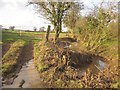
Tributary of the Folly Brook
The stream is the parish boundary between Mangotsfield Rural (left) and Pucklechurch. Here it is crossed by Howsmoor Lane.
Image: © Derek Harper
Taken: 22 Nov 2013
0.17 miles