IMAGES TAKEN NEAR TO
Kings Walk, BRISTOL, BS13 8AX
Introduction
This page details the photographs taken nearby to Kings Walk, BS13 8AX by members of the Geograph project.
The Geograph project started in 2005 with the aim of publishing, organising and preserving representative images for every square kilometre of Great Britain, Ireland and the Isle of Man.

There are currently over 7.5m images from over14,400 individuals and you can help contribute to the project by visiting https://www.geograph.org.uk
Image Map
Images are licensed for reuse under creativecommons.org/licenses/by-sa/2.0
Notes
- Clicking on the map will re-center to the selected point.
- The higher the marker number, the further away the image location is from the centre of the postcode.
Image Listing (15 Images Found)
Images are licensed for reuse under creativecommons.org/licenses/by-sa/2.0
Image
Details
Distance
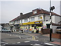
1
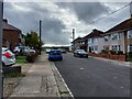
Highridge Walk
An unpretentious cul-de-sac of semi-detached houses, ending in a relaxing view across Bedminster Down School's playing fields https://sports-facilities.co.uk/sites/view/1204508 .
Image: © HelenK
Taken: 25 Oct 2022
0.06 miles
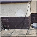
3
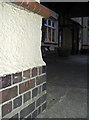
Cut benchmark on the King's Head, Bristol
Once there used to be a flush bracket here, but it seems to have been lost. However, a simple cutmark has been made close to the original position, although its date may be several years apart.
See http://www.bench-marks.org.uk/bm786 for the Benchmark Database.
Image: © Neil Owen
Taken: 26 Jul 2011
0.07 miles
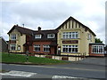
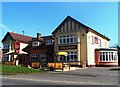
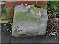
5
Ordnance Survey Cut Mark
This OS cut mark can be found on The Kings Head PH. It marks a point 62.725m above mean sea level.
Image: © Adrian Dust
Taken: 5 Aug 2022
0.08 miles
7
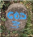
Old Boundary Marker on Highridge Green, Bristol
Parish Boundary Marker on the west side of Highridge Green, Highridge, Bristol, against the front garden gatepost of no.2. Shown on OS maps surveyed in 1882 on the boundary of Bedminster and Long Ashton parishes. From 1894 it was on the boundary of Bedminster Without and Long Ashton and from 1898 Bishopsworth and Long Ashton. Since 1951 it has been completely within the Bristol boundary.
Milestone Society National ID: SO_BRIS26pb
Image: © Roadside Relics
Taken: 7 Jan 2020
0.09 miles
8
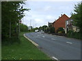
Bridgwater Road (A38)
Heading north east towards Bristol.
Image: © JThomas
Taken: 10 May 2013
0.10 miles
9
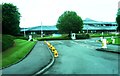
Entrance to office complex off Bridgwater Road
Located at roundabout on the A38
Image: © Clint Mann
Taken: 3 Sep 2015
0.11 miles
10
Old Boundary Marker by the A38, Bridgwater Road, Long Ashton parish
Parish Boundary Marker by the A38, in parish of Long Ashton (North Somerset District), Bridgwater Road, beside stile on Southeast side of road.
To be surveyed
Milestone Society National ID: SO_LASBRI01pb
Image: © Milestone Society
Taken: Unknown
0.12 miles