IMAGES TAKEN NEAR TO
Sherlies Avenue, ORPINGTON, BR6 9RE
Introduction
This page details the photographs taken nearby to Sherlies Avenue, BR6 9RE by members of the Geograph project.
The Geograph project started in 2005 with the aim of publishing, organising and preserving representative images for every square kilometre of Great Britain, Ireland and the Isle of Man.

There are currently over 7.5m images from over14,400 individuals and you can help contribute to the project by visiting https://www.geograph.org.uk
Image Map (Loading...)


Getting Data...Please wait
Leaflet Map data © OpenStreetMap
Images are licensed for reuse under creativecommons.org/licenses/by-sa/2.0
Notes
- Clicking on the map will re-center to the selected point.
- The higher the marker number, the further away the image location is from the centre of the postcode.
Image Listing (177 Images Found)
Images are licensed for reuse under creativecommons.org/licenses/by-sa/2.0
Image
Details
Distance
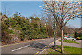
1
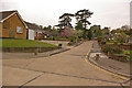
Thorpe Close
Sherlies was the name of a country house built in 1870, one of 5 large houses on the north side of Tubbenden Lane to the south of Orpington Station, the others being (from east to west) Northolme, The Alchornes, Fernbank and Sunnyside. All these other four are shown in the 1881 census with the name "Sherlies" next to the house name, suggesting that they were all part of the same original plot, subdivided for building purposes.
Sherlies itself was set in extensive grounds, on rising land with views over (what was then) farmland to the south east. In Spring 1915 it was used briefly by VAD (Voluntary Aid Detachment - an organisation formed jointly by the Red Cross with the Order of St John of Jerusalem) patients. In 1920 it became a hotel, in which guise it served its final years.
All the houses have since been demolished, at different times, with their sites developed for housing. The style of housing suggests that Sherlies was the first of the houses to be demolished, with the site and grounds being used to build Sherlies Avenue, Telscombe Close and Thorpe Close.
This is Thorpe Close at its junction with Sherlies Avenue - comparison with the 1910 6 inch map shows that the site of Sherlies itself was two thirds of the way up this road.
With thanks to local resident Calvin Wickham for help with the research into the history of this house and its neighbours.
Image: © Ian Capper
Taken: 16 Apr 2009
0.02 miles
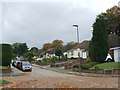
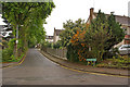
2
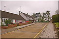
Sherlies Avenue
Sherlies was the name of a country house built in 1870, one of 5 large houses on the north side of Tubbenden Lane to the south of Orpington Station, the others being (from east to west) Northolme, The Alchornes, Fernbank and Sunnyside. All these other four are shown in the 1881 census with the name "Sherlies" next to the house name, suggesting that they were all part of the same original plot, subdivided for building purposes.
Sherlies itself was set in extensive grounds, on rising land with views over (what was then) farmland to the south east. In Spring 1915 it was used briefly by VAD (Voluntary Aid Detachment - an organisation formed jointly by the Red Cross with the Order of St John of Jerusalem) patients. In 1920 it became a hotel, in which guise it served its final years.
All the houses have since been demolished, at different times, with their sites developed for housing. The style of housing suggests that Sherlies was the first of the houses to be demolished, with the site and grounds being used to build Sherlies Avenue, Telscombe Close and Thorpe Close.
This photo shows part of Sherlies Avenue. A footpath is shown on the 1910 6 inch map running between Sherlies and its neighbour, Northolme. The footpath remains, running between the bungalow on the left of the photo and the house beyond, and then continues up to Newstead Avenue. The abrupt change in style of housing, both in Sherlies Avenue as seen here and the parallel Woodhead Drive, suggests that this was the original limit of Sherlies Avenue, with the development of the site of Northolme following later.
With thanks to local resident Calvin Wickham for help with the research into the history of Sherlies and its neighbours.
Image: © Ian Capper
Taken: 17 Apr 2009
0.04 miles
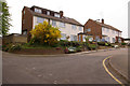
3
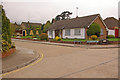
Sherlies Avenue
Sherlies was the name of a country house built in 1870, one of 5 large houses on the north side of Tubbenden Lane to the south of Orpington Station, the others being (from east to west) Northolme, The Alchornes, Fernbank and Sunnyside. All these other four are shown in the 1881 census with the name "Sherlies" next to the house name, suggesting that they were all part of the same original plot, subdivided for building purposes.
Sherlies itself was set in extensive grounds, on rising land with views over (what was then) farmland to the south east. In Spring 1915 it was used briefly by VAD (Voluntary Aid Detachment - an organisation formed jointly by the Red Cross with the Order of St John of Jerusalem) patients. In 1920 it became a hotel, in which guise it served its final years.
All the houses have since been demolished, at different times, with their sites developed for housing. The style of housing suggests that Sherlies was the first of the houses to be demolished, with the site and grounds being used to build Sherlies Avenue, Telscombe Close and Thorpe Close.
Comparison with the 1910 6 inch map shows that the route of Sherlies Avenue follows the course of the original driveway to Sherlies. This photo shows the road following the bend in the original drive, with Telscombe Close continuing straight on, being on what was the gardens for Sherlies.
With thanks to local resident Calvin Wickham for help with the research into the history of Sherlies and its neighbours.
Image: © Ian Capper
Taken: 16 Apr 2009
0.04 miles
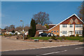
4
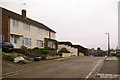
Sherlies Avenue
See Image This is another view of the later section of Sherlies Avenue, which would appear to have been built as part of the development of the Northolme site. The footpath referred to in Image, seen here on the north side of Sherlies Avenue, runs behind the prominent white wall beyond the house on the left.
Image: © Ian Capper
Taken: 17 Apr 2009
0.04 miles
5
Tubbenden Lane
An old route from Orpington to Farnborough. The wall and line of trees on the left marks the front boundary of a row of large houses built in the 1870s - Sunnyside, Fernbank, The Alchornes, Northolme and Sherlies, of which Sunnyside was notable as the home of George Allen, publisher to John Ruskin. The area was subsequently redeveloped in stages from the 1960s onwards, with Sherlies (the largest plot) being demolished first.
Image: © Ian Capper
Taken: 29 Mar 2012
0.05 miles
6

Sherlies Avenue
Sherlies was the name of a country house built in 1870, one of 5 large houses on the north side of Tubbenden Lane to the south of Orpington Station, the others being (from east to west) Northolme, The Alchornes, Fernbank and Sunnyside. All these other four are shown in the 1881 census with the name "Sherlies" next to the house name, suggesting that they were all part of the same original plot, subdivided for building purposes.
Sherlies itself was set in extensive grounds, on rising land with views over (what was then) farmland to the south east. In Spring 1915 it was used briefly by VAD (Voluntary Aid Detachment - an organisation formed jointly by the Red Cross with the Order of St John of Jerusalem) patients. In 1920 it became a hotel, in which guise it served its final years.
All the houses have since been demolished, at different times, with their sites developed for housing. The style of housing suggests that Sherlies was the first of the houses to be demolished, with the site and grounds being used to build Sherlies Avenue, Telscombe Close and Thorpe Close.
This photo shows Sherlies Avenue at the point it leaves Tubbenden Lane. Comparison with the 1910 6 inch map shows that the route of the road follows the course of the original driveway to Sherlies, including a left hand bend half way along it (see Image).
With thanks to local resident Calvin Wickham for help with the research into the history of Sherlies and its neighbours.
Image: © Ian Capper
Taken: 14 Apr 2009
0.06 miles
8
Sherlies Avenue
In the 1870s 5 large houses were built on the north side of Tubbenden Lane to the south of Orpington Station, the largest and easternmost being called Sherlies with the others being (from east to west) Northolme, The Alchornes, Fernbank and Sunnyside. All these other four are shown in the 1881 census with the name "Sherlies" next to the house name, suggesting that they were all part of the same original plot, subdivided for building purposes.
All the houses have since been demolished, at different times, with their sites developed for housing.
This is Sherlies Avenue at its junction with Northolme Rise. As explained in Image, this section of Sherlies Avenue would appear to be of a later date than the remainder, built at the same time as Northolme, on which this section stands, was developed.
With thanks to local resident Calvin Wickham for help with the research into the history of Sherlies and its neighbours.
Image: © Ian Capper
Taken: 14 Apr 2009
0.06 miles
9
Sherlies Avenue
1960s housing off Tubbenden Lane.
Sherlies was the name of a country house built in 1870, one of 5 large houses on the north side of Tubbenden Lane to the south of Orpington Station, the others being (from east to west) Northolme, The Alchornes, Fernbank and Sunnyside. All these other four are shown in the 1881 census with the name "Sherlies" next to the house name, suggesting that they were all part of the same original plot, subdivided for building purposes.
Sherlies itself was set in extensive grounds, on rising land with views over (what was then) farmland to the south east. In Spring 1915 it was used briefly by VAD (Voluntary Aid Detachment - an organisation formed jointly by the Red Cross with the Order of St John of Jerusalem) patients. In 1920 it became a hotel, in which guise it served its final years.
All the houses have since been demolished, at different times, with their sites developed for housing. The 1961 1:2,500 map shows suggests that Sherlies was the first of the houses to be demolished, with the site and grounds being used to build Sherlies Avenue, Telscombe Close and Thorpe Close.
This photo shows Sherlies Avenue at the point it leaves Tubbenden Lane. Comparison with the 1910 6 inch map shows that the route of the road follows the course of the original driveway to Sherlies, including a left hand bend half way along it (see Image).
With thanks to local resident Calvin Wickham for help with the research into the history of Sherlies and its neighbours.
Image: © Ian Capper
Taken: 29 Mar 2012
0.06 miles
10
Northolme Rise
In the 1870s 5 large houses were built on the north side of Tubbenden Lane to the south of Orpington Station, the largest and easternmost being called Sherlies with the others being (from east to west) Northolme, The Alchornes, Fernbank and Sunnyside. All these other four are shown in the 1881 census with the name "Sherlies" next to the house name, suggesting that they were all part of the same original plot, subdivided for building purposes.
All the houses have since been demolished, at different times, with their sites developed for housing.
This is Northolme Rise - comparison with the 1910 6 inch map shows that it follows the route of the former driveway of Northolme. The style of housing suggests that Northolme and its gardens was developed later than Sherlies but before the other neighbouring houses.
With thanks to local resident Calvin Wickham for help with the research into the history of Sherlies and its neighbours.
Image: © Ian Capper
Taken: 17 Apr 2009
0.07 miles