IMAGES TAKEN NEAR TO
Court Road, ORPINGTON, BR6 0PX
Introduction
This page details the photographs taken nearby to Court Road, BR6 0PX by members of the Geograph project.
The Geograph project started in 2005 with the aim of publishing, organising and preserving representative images for every square kilometre of Great Britain, Ireland and the Isle of Man.

There are currently over 7.5m images from over14,400 individuals and you can help contribute to the project by visiting https://www.geograph.org.uk
Image Map
Images are licensed for reuse under creativecommons.org/licenses/by-sa/2.0
Notes
- Clicking on the map will re-center to the selected point.
- The higher the marker number, the further away the image location is from the centre of the postcode.
Image Listing (28 Images Found)
Images are licensed for reuse under creativecommons.org/licenses/by-sa/2.0
Image
Details
Distance
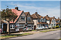
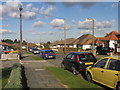
1
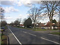
Court Road
Part of the Orpington bypass, built in the 1920s. As with a lot of the development in the Orpington area, the houses in this picture are all bungalows.
Image: © Ian Capper
Taken: 6 Feb 2008
0.08 miles
2
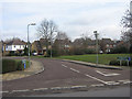
Bodmin Close
Giving access to the Bromley Indoor Bowls Centre (see Image) and Glastonbury Close (the road for the houses in the photo). This area was previously the site of the Ramsden School for Boys, which closed in 1992. The housing here dates from 1997.
Image: © Ian Capper
Taken: 16 Feb 2009
0.09 miles
3
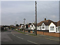
Bedford Road
Bungalows in Bedford Road, one of a number of roads in this part of Orpington named after public schools.
Image: © Ian Capper
Taken: 16 Feb 2009
0.11 miles
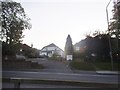
4
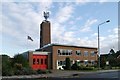
Orpington fire station
Orpington fire station, 13 Avalon Road, Orpington, is one of London Fire Brigade's 100 plus fire stations, and was opened in 1958.
Image: © Kevin Hale
Taken: 17 Oct 2007
0.13 miles
5
Gillmans Road
Road developed either side of the Second World War. The 1945 6 inch map (based on 1938 revisions) show it as Gilmans Road (with a single "l").
Image: © Ian Capper
Taken: 18 Jul 2014
0.13 miles
7
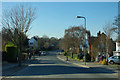
Tintagel Road
Outer suburban Orpington.
Image: © Robin Webster
Taken: 3 Feb 2012
0.14 miles
8
Lancelot Court
A development of flats in Avalon Road near its junction with Court Road, the name maintaining the Arthurian theme of a number of roads in this part of Orpington.
Image: © Ian Capper
Taken: 16 Feb 2009
0.14 miles
9

Orpington Fire Station
Situated on Avalon Road at its junction with Gillmans Road, and conveniently close to the A224 Court Road (Orpington Bypass) giving easy access to a wider area. The Fire Station was built in 1958.
Planning permission has been granted for its demolition and replacement over 2013-14.
Image: © Ian Capper
Taken: 22 May 2012
0.14 miles
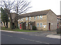
10
Bedford Road
One of the "public schools" roads in this part of Orpington. The housing in this road is mainly bungalows.
Image: © Ian Capper
Taken: 6 Feb 2008
0.15 miles