IMAGES TAKEN NEAR TO
Streat Lane, HASSOCKS, BN6 8RR
Introduction
This page details the photographs taken nearby to Streat Lane, BN6 8RR by members of the Geograph project.
The Geograph project started in 2005 with the aim of publishing, organising and preserving representative images for every square kilometre of Great Britain, Ireland and the Isle of Man.

There are currently over 7.5m images from over14,400 individuals and you can help contribute to the project by visiting https://www.geograph.org.uk
Image Map (Loading...)


Getting Data...Please wait
Leaflet Map data © OpenStreetMap
Images are licensed for reuse under creativecommons.org/licenses/by-sa/2.0
Notes
- Clicking on the map will re-center to the selected point.
- The higher the marker number, the further away the image location is from the centre of the postcode.
Image Listing (7 Images Found)
Images are licensed for reuse under creativecommons.org/licenses/by-sa/2.0
Image
Details
Distance
1
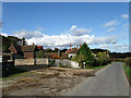
Oakwood Farm
The farmhouse is the red tiled building to the rear, the grey weatherboarded house being Blabers Mead named after a nearby field. Oakwood stables are out of shot to the left whilst Streat Lane is the road on the right.
Image: © Simon Carey
Taken: 4 Nov 2009
0.01 miles
2
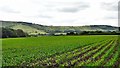
Cow Field
The name of the field according to the 1838 tithe map. By the 1970s the large field had been divided into four but has since been enlarged again with the exception of a small number of paddocks next to Streat Lane out of shot to the right. Broad Bush Wood is in the distance.
Image: © Simon Carey
Taken: 4 Nov 2009
0.07 miles
3
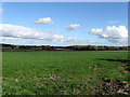
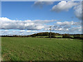
Ox Pasture
The name of the field according to the 1838 tithe map. Broad Bush Wood is in the distance.
Image: © Simon Carey
Taken: 4 Nov 2009
0.10 miles
4
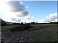
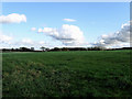
Park Field
The name of the field according to the 1838 tithe map. The foreground including the heap of manure is in this square whilst the rest is in the adjoining one. Middleton Manor can just be made out over the manure in the distance.
Image: © Simon Carey
Taken: 4 Nov 2009
0.13 miles
5
Silver Mead (2)
The name of the field according to the 1838 tithe map. This is the southern end as it gradually slopes down towards a small unnamed stream. Plumpton Wood is in the distance.
Image: © Simon Carey
Taken: 4 Nov 2009
0.21 miles
6
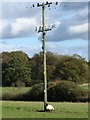
Scratching that Itch
A ewe uses the telegraph pole to locate that spot on the back that needs a little scratch. See Image for a view of the field.
Image: © Simon Carey
Taken: 4 Nov 2009
0.23 miles