IMAGES TAKEN NEAR TO
The Drive, HOVE, BN3 3PG
Introduction
This page details the photographs taken nearby to The Drive, BN3 3PG by members of the Geograph project.
The Geograph project started in 2005 with the aim of publishing, organising and preserving representative images for every square kilometre of Great Britain, Ireland and the Isle of Man.

There are currently over 7.5m images from over14,400 individuals and you can help contribute to the project by visiting https://www.geograph.org.uk
Image Map
Images are licensed for reuse under creativecommons.org/licenses/by-sa/2.0
Notes
- Clicking on the map will re-center to the selected point.
- The higher the marker number, the further away the image location is from the centre of the postcode.
Image Listing (243 Images Found)
Images are licensed for reuse under creativecommons.org/licenses/by-sa/2.0
Image
Details
Distance
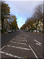
1
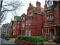
69-75, The Drive
Late nineteenth century terracotta mansions with a touch of gothic built for the great and good of the era. Nowadays, like most top end Victorian buildings in this area, they have been subdivided into flats. The less fortunate have been demolished altogether and replaced by more modern faceless apartment blocks. The Drive is the B2185 that runs from the seafront to the A270 Old Shoreham Road. These houses are south of the crossroads with the B2120 Cromwell Road on the west side of the road. This view looks south.
Image: © Simon Carey
Taken: 1 Jan 2006
0.01 miles
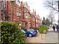
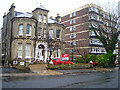
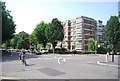
3
Elizabeth Court, Wilbury Road
This retirement block along with Phillip Court occupies the area bounded by The Drive (B2185) to the west, Cromwell Road (B2120) to the north and Wilbury Road to the east. When the latter was laid out in the 1890s this area was given over to the Wilbury Road Lawn Tennis Club who retained occupancy of the area until the 1970s when it was closed and these blocks were built in its place. This view looks from Wilbury Road in a northerly direction towards Elizabeth Court.
Image: © Simon Carey
Taken: 12 Mar 2006
0.05 miles
4
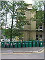
Wheelie Bins, The Drive
Standing in a line outside the Embassy Language School for foreign students at the north west side of the crossroads of The Drive (B2186) and Cromwell Road (B2120).
Image: © Simon Carey
Taken: 16 Sep 2006
0.06 miles
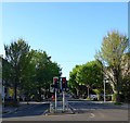
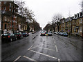
5
The Drive
The B2186 which links Kingsway and Old Shoreham Road. Laid out when the Stanford estate was developed in the 1870s hence the straightness of the road. This part lies between Eaton Road and Cromwell Road.
Image: © Simon Carey
Taken: 26 Nov 2006
0.07 miles
6
The Drive, Hove
The B2185 heading north from the junction with Eaton Road.
Image: © Simon Carey
Taken: 8 May 2020
0.07 miles
7
The old and the new, Eaton Gardens
The building on the left was once part of a number of similarly built gothic style Victorian mansions that lined this side of the street. This one has survivied because it has become a nursing home. Unfortunately, its neighbours either side have succumbed and become a modern block of flats. This is very much the trend in Hove as the land these mansions are built on become more valuable than the buildings themselves. Mansions like these can be converted into 8 or 9 flats but there is more money in taller, newer blocks. Eaton Gardens runs south from the B2120 its southerly junction being split between this square and TQ2804. This picture has been taken halfway down the road and looks to the east.
Image: © Simon Carey
Taken: 8 Jan 2006
0.08 miles
8
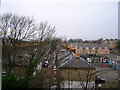
Cambridge Grove, Hove
Cambridge Grove is very reminiscent of the mews like streets of Kensington, a small mews that runs parallel with Cromwell Road (B2120) and the railway between Wilbury Villas and The Drive (B2185). All the houses are built on top of garages. The houses to the right form Cambridge Mews erected four years ago on the site of a former parcel depot. The light industrial units in the foreground to the right are part of the front view of Image] one of the first set up in Britain. This view looks west and was taken from my flat. On a clearer day the South Downs can be seen in the distance.
Image: © Simon Carey
Taken: 14 Jan 2006
0.08 miles
10
Wilbury Road
This part of Hove was built up from the 1870s onwards when the Stanford Estate was given over to commercial development. This minor road heads south to the sea and gives some idea to space afforded to the roads and avenues for the well to do, consequently unlike many other Victorian roads this one is wide enough to have room for cars to park in the middle. The original buildings are by and large untouched with the exception of a few blocks of flats on the eastern side. This view looks south from the curve in the road near the junction with the B2120.
Image: © Simon Carey
Taken: 19 Feb 2006
0.08 miles