IMAGES TAKEN NEAR TO
Cissbury Crescent, BRIGHTON, BN2 8PN
Introduction
This page details the photographs taken nearby to Cissbury Crescent, BN2 8PN by members of the Geograph project.
The Geograph project started in 2005 with the aim of publishing, organising and preserving representative images for every square kilometre of Great Britain, Ireland and the Isle of Man.

There are currently over 7.5m images from over14,400 individuals and you can help contribute to the project by visiting https://www.geograph.org.uk
Image Map
Images are licensed for reuse under creativecommons.org/licenses/by-sa/2.0
Notes
- Clicking on the map will re-center to the selected point.
- The higher the marker number, the further away the image location is from the centre of the postcode.
Image Listing (49 Images Found)
Images are licensed for reuse under creativecommons.org/licenses/by-sa/2.0
Image
Details
Distance
1
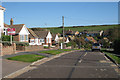
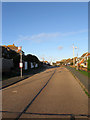
Bevendean Avenue
The Avenue is one of the roads through Saltdean crossing the boundary between Brighton & Hove City Council and East Sussex Council at the Junction with Longridge Avenue. The Eastern end of the avenue is at the edge of Telscombe Tye
Image: © Paul Gillett
Taken: 30 May 2009
0.05 miles
2
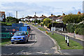
Hartfield Road, Saltdean
Small link road that runs between Rodmell Avenue and Cissbury Crescent that wasn't part of the original plans but seems to have been added sometime in the late 1930s or 40s. The land drops down here into what was once Bannings Bottom with Telscombe Tye the large green swathe of land beyond.
Image: © Simon Carey
Taken: 27 Oct 2012
0.05 miles

4
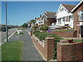
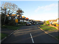
Rodmell Avenue, Saltdean
The road runs from Shepham Avenue in the west to Bannings Vale in the east and was marked out in the 1920s though development was slow and was not completed until the 1960s. Viewed from the junction with Hartfield Road.
Image: © Simon Carey
Taken: 27 Oct 2012
0.10 miles
5
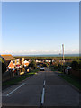
Cissbury Crescent, Saltdean
The road runs in an arc with both junctions on Bannings Vale and is one of the original ones laid out in the 1920s though this section running eastwards from Hartfield Road remained undeveloped until the mid 1960s.
Image: © Simon Carey
Taken: 27 Oct 2012
0.10 miles
6
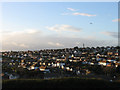
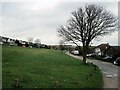
East Saltdean
Viewed from Telscombe Tye and accentuating the layout of the suburb where the roads have generally followed the contour line. This part of Saltdean is part of Telscombe parish and local council as opposed to the rest that lies within the borough of Brighton. and was the last part to be fully developed when the remainder of the empty plots was built upon in the 1960s and 70s.
Image: © Simon Carey
Taken: 27 Oct 2012
0.11 miles
7
Findon Avenue, Saltdean
One of the original roads of the 1920s which along with neighbouring Image was one of the few in eastern Saltdean to be fully developed before the Second World War. Both roads remain unmade today and open out onto small greens.
Image: © Simon Carey
Taken: 27 Oct 2012
0.12 miles
8
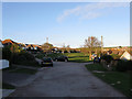
Findon Avenue, Saltdean
Unmade Road off Bevendean Avenue
Image: © Paul Gillett
Taken: 25 Dec 2012
0.13 miles