IMAGES TAKEN NEAR TO
Cissbury Crescent, BRIGHTON, BN2 8EN
Introduction
This page details the photographs taken nearby to Cissbury Crescent, BN2 8EN by members of the Geograph project.
The Geograph project started in 2005 with the aim of publishing, organising and preserving representative images for every square kilometre of Great Britain, Ireland and the Isle of Man.

There are currently over 7.5m images from over14,400 individuals and you can help contribute to the project by visiting https://www.geograph.org.uk
Image Map
Images are licensed for reuse under creativecommons.org/licenses/by-sa/2.0
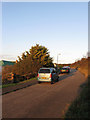
Notes
- Clicking on the map will re-center to the selected point.
- The higher the marker number, the further away the image location is from the centre of the postcode.
Image Listing (37 Images Found)
Images are licensed for reuse under creativecommons.org/licenses/by-sa/2.0
Image
Details
Distance
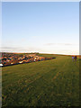
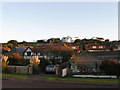
1
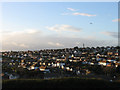
East Saltdean
Viewed from Telscombe Tye and accentuating the layout of the suburb where the roads have generally followed the contour line. This part of Saltdean is part of Telscombe parish and local council as opposed to the rest that lies within the borough of Brighton. and was the last part to be fully developed when the remainder of the empty plots was built upon in the 1960s and 70s.
Image: © Simon Carey
Taken: 27 Oct 2012
0.05 miles
2
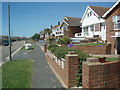
Bevendean Avenue
The Avenue is one of the roads through Saltdean crossing the boundary between Brighton & Hove City Council and East Sussex Council at the Junction with Longridge Avenue. The Eastern end of the avenue is at the edge of Telscombe Tye
Image: © Paul Gillett
Taken: 30 May 2009
0.11 miles

5
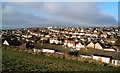
Saltdean viewed from Telscombe Tye
photo taken on Christmas Day 2009
Image: © Paul Gillett
Taken: 25 Dec 2009
0.13 miles
6
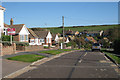
Ashurst Avenue, Saltdean
The road runs from Hamsey Road in the south to Bevendean Avenue in the north and lies next to Telscombe Tye.
Image: © Simon Carey
Taken: 27 Oct 2012
0.14 miles
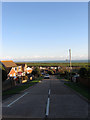
7
Telscombe Tye
The western end of the common that separates Telscombe Cliffs to Saltdean on the left. The portion of the latter in view occupies the area once known as Bannings Bottom.
Image: © Simon Carey
Taken: 27 Oct 2012
0.15 miles
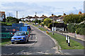
8
Hartfield Road, Saltdean
Small link road that runs between Rodmell Avenue and Cissbury Crescent that wasn't part of the original plans but seems to have been added sometime in the late 1930s or 40s. The land drops down here into what was once Bannings Bottom with Telscombe Tye the large green swathe of land beyond.
Image: © Simon Carey
Taken: 27 Oct 2012
0.16 miles
10
38-42 Bannings Vale, Saltdean
The numbers pertain to the buildings on the left some of which once belonged to a farm called Lower Bannings. The oldest part is the barn, whose roof is visible on the left whilst the houses to the right are built within the site of another set of barns and seem to utilise a good deal of flint. The farmhouse appears to have been pulled down in 1934.
Image: © Simon Carey
Taken: 27 Oct 2012
0.17 miles