IMAGES TAKEN NEAR TO
Hamsey Road, BRIGHTON, BN2 8EH
Introduction
This page details the photographs taken nearby to Hamsey Road, BN2 8EH by members of the Geograph project.
The Geograph project started in 2005 with the aim of publishing, organising and preserving representative images for every square kilometre of Great Britain, Ireland and the Isle of Man.

There are currently over 7.5m images from over14,400 individuals and you can help contribute to the project by visiting https://www.geograph.org.uk
Image Map
Images are licensed for reuse under creativecommons.org/licenses/by-sa/2.0
Notes
- Clicking on the map will re-center to the selected point.
- The higher the marker number, the further away the image location is from the centre of the postcode.
Image Listing (27 Images Found)
Images are licensed for reuse under creativecommons.org/licenses/by-sa/2.0
Image
Details
Distance
1
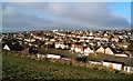
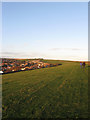
Saltdean viewed from Telscombe Tye
photo taken on Christmas Day 2009
Image: © Paul Gillett
Taken: 25 Dec 2009
0.07 miles
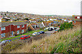
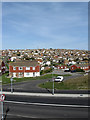
2
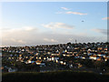
East Saltdean
Viewed from Telscombe Tye and accentuating the layout of the suburb where the roads have generally followed the contour line. This part of Saltdean is part of Telscombe parish and local council as opposed to the rest that lies within the borough of Brighton. and was the last part to be fully developed when the remainder of the empty plots was built upon in the 1960s and 70s.
Image: © Simon Carey
Taken: 27 Oct 2012
0.09 miles
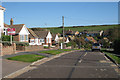
3
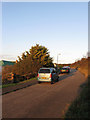
Ashurst Avenue, Saltdean
The road runs from Hamsey Road in the south to Bevendean Avenue in the north and lies next to Telscombe Tye.
Image: © Simon Carey
Taken: 27 Oct 2012
0.09 miles
4
38-42 Bannings Vale, Saltdean
The numbers pertain to the buildings on the left some of which once belonged to a farm called Lower Bannings. The oldest part is the barn, whose roof is visible on the left whilst the houses to the right are built within the site of another set of barns and seem to utilise a good deal of flint. The farmhouse appears to have been pulled down in 1934.
Image: © Simon Carey
Taken: 27 Oct 2012
0.11 miles
5
Telscombe Tye
The western end of the common that separates Telscombe Cliffs to Saltdean on the left. The portion of the latter in view occupies the area once known as Bannings Bottom.
Image: © Simon Carey
Taken: 27 Oct 2012
0.14 miles
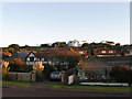
6
Hamsey Road and beyond
Viewed from Tye Close. The Tye is Telscombe Tye, which has foot access from the end of the close.
Image: © Robin Webster
Taken: 27 Feb 2010
0.14 miles
8
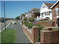
Bevendean Avenue
The Avenue is one of the roads through Saltdean crossing the boundary between Brighton & Hove City Council and East Sussex Council at the Junction with Longridge Avenue. The Eastern end of the avenue is at the edge of Telscombe Tye
Image: © Paul Gillett
Taken: 30 May 2009
0.17 miles
9
East Saltdean
Taken overlooking the junction of South Coast Road, the A259, and Hamsey Road. Saltdean was created after the First World War by entrepreneur Charles Neville also responsible for nearby Peacehaven on what had been open downland populated by sheep for the previous centuries. The nature of landholding meany Neville purchased land that crossed an ancient hundred boundary resulting in the fact that the today the suburb of Saltdean is administered by two separate councils. East Saltdean is governed by the parish council at Telscombe which in turn is answerable to Lewes District Council. Saltdean to the west of Longridge Avenue is run by Brighton & Hove City Council. When I was a teenager living in nearby Peacehaven late night revelries resulting in returning after the last bus meant getting a Brighton taxi to this point then walking the rest of the way because the then policy of having to pay for the taxi's return journey.
Image: © Simon Carey
Taken: 15 Mar 2009
0.17 miles
