IMAGES TAKEN NEAR TO
Hawth Hill, SEAFORD, BN25 2RL
Introduction
This page details the photographs taken nearby to Hawth Hill, BN25 2RL by members of the Geograph project.
The Geograph project started in 2005 with the aim of publishing, organising and preserving representative images for every square kilometre of Great Britain, Ireland and the Isle of Man.

There are currently over 7.5m images from over14,400 individuals and you can help contribute to the project by visiting https://www.geograph.org.uk
Image Map
Images are licensed for reuse under creativecommons.org/licenses/by-sa/2.0
Notes
- Clicking on the map will re-center to the selected point.
- The higher the marker number, the further away the image location is from the centre of the postcode.
Image Listing (73 Images Found)
Images are licensed for reuse under creativecommons.org/licenses/by-sa/2.0
Image
Details
Distance
2
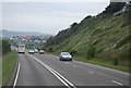
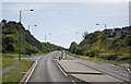
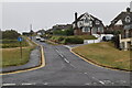
Buckle By-Pass
Carrying the A259 up Hawth Hill. The by-pass was built in 1963 to replace the old route that travelled around the southern end of Hawth Hill next to the sea before rejoining the current route via Claremont Road. A railway bridge with a width restriction along with another that had a weight restriction allied to frequent flooding of the coastal road were factors in building the by-pass.
Image: © Simon Carey
Taken: 15 Nov 2009
0.04 miles
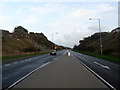
4
Buckle bypass
The Buckle Bypass is the main road from Newhaven to Seaford
Until the Buckle Bypass was built in 1963, the main road from Newhaven ran under the Rail bridge and past the Buckle Pub into Seaford. In the winter it was often closed due to high seas http://www.sussex-opc.org/index.php?k=175&t=Parish
Image: © Paul Gillett
Taken: 28 Mar 2010
0.05 miles
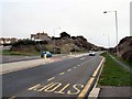
5
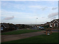
Hawth Park Road
Post war housing estate built on Hawth Hill.
Image: © Simon Carey
Taken: 15 Nov 2009
0.07 miles
7
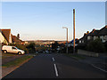
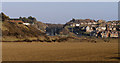
Hill Rise
Built on Hawth Hill in the 1930s to provide the spine along with Image and Image for a projected new town based around Bishopstone. A few houses and a new station had been constructed by the time the Second World War bought proceedings to a halt. Post war shortages and the tougher 1947 Town Planning Act ended plans for the new town with development limited to infilling on this road and the completion of a small self contained estate on Rookery Hill in the early 1970s. The town of Newhaven can be seen in the distance.
Image: © Simon Carey
Taken: 26 Aug 2012
0.09 miles
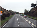
10
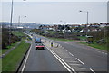
Buckle Bypass, Seaford.
The Buckle Bypass cuts through Hawth Hill and was opened in 1963 to avoid traffic having to negotiate Marine Parade which was often flooded during high tides.
Image: © Kevin Gordon
Taken: 1 Mar 2008
0.11 miles