IMAGES TAKEN NEAR TO
Crossbush Lane, ARUNDEL, BN18 9PN
Introduction
This page details the photographs taken nearby to Crossbush Lane, BN18 9PN by members of the Geograph project.
The Geograph project started in 2005 with the aim of publishing, organising and preserving representative images for every square kilometre of Great Britain, Ireland and the Isle of Man.

There are currently over 7.5m images from over14,400 individuals and you can help contribute to the project by visiting https://www.geograph.org.uk
Image Map
Images are licensed for reuse under creativecommons.org/licenses/by-sa/2.0
Notes
- Clicking on the map will re-center to the selected point.
- The higher the marker number, the further away the image location is from the centre of the postcode.
Image Listing (23 Images Found)
Images are licensed for reuse under creativecommons.org/licenses/by-sa/2.0
Image
Details
Distance
1
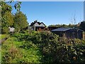
Sheds near Poling Corner, Crossbush Lane
Image: © Jeff Gogarty
Taken: 20 Oct 2022
0.00 miles
2
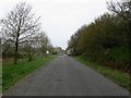
Crossbush Lane
Until the early 1990s this was the main A27 having just reverted to a single carriageway west of Poling Corner. Now a quiet backwater enabling the cars in the distance to park carefree outside their homes in Pottery Cottages.
Image: © Simon Carey
Taken: 13 Apr 2009
0.01 miles
3
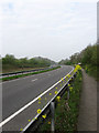
Crossbush By-Pass
The old route of the A27 would have branched off to the right at the white building just visible beyond the rape plants lining the crash barrier. The new route was the beginning of a full Arundel by-pass that only got as far as the junction with the A284. At present the scheme to take it across the river south of Arundel has been put on hold until 2016 which means another 7 years of notorious bottlenecks and snarl ups.
Image: © Simon Carey
Taken: 13 Apr 2009
0.05 miles
5
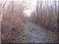
Footpath north through Poling Copse
This footpath leads from the small dead end road near Crossbush. Which at one time was the main A27 trunk road which now runs parallel.
Image: © Dave Spicer
Taken: 18 Jan 2009
0.11 miles
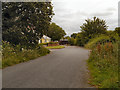
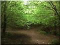
6
Footpath Junction, Poling Copse
The path from Crossbush Lane to Clay Lane runs left to route, that linking Blakehurst Lane and Crossbush runs straight ahead.
Image: © Simon Carey
Taken: 13 Apr 2009
0.13 miles
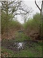
7
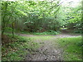
Crossing of Footpaths
The north-south path from Clay Lane to Crossbush Lane crosses the east-west on that links Blakehurst Lane to Crossbush Lane. The latter is also a boundary between two sets of woodland; Poling Copse to the south of the path and The Isles to the north.
Image: © Simon Carey
Taken: 20 Aug 2013
0.14 miles
8
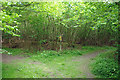
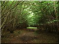
Footpath crossways, Poling Copse
Poling Copse is much more like a copse than other "copses" around here - largely hazel with a more interesting ground flora - let us hope it will be coppiced again in the traditional manner.
Image: © Robin Webster
Taken: 30 May 2010
0.14 miles
10
Footpath to Blakehurst Lane
Linking the lane with Crossbush Lane to the west. The footpath is a boundary between Poling Copse on the right and The Isles to the left.
Image: © Simon Carey
Taken: 20 Aug 2013
0.14 miles