IMAGES TAKEN NEAR TO
Fernside Road, BOURNEMOUTH, BH9 2LB
Introduction
This page details the photographs taken nearby to Fernside Road, BH9 2LB by members of the Geograph project.
The Geograph project started in 2005 with the aim of publishing, organising and preserving representative images for every square kilometre of Great Britain, Ireland and the Isle of Man.

There are currently over 7.5m images from over14,400 individuals and you can help contribute to the project by visiting https://www.geograph.org.uk
Image Map
Images are licensed for reuse under creativecommons.org/licenses/by-sa/2.0
Notes
- Clicking on the map will re-center to the selected point.
- The higher the marker number, the further away the image location is from the centre of the postcode.
Image Listing (125 Images Found)
Images are licensed for reuse under creativecommons.org/licenses/by-sa/2.0
Image
Details
Distance
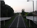
1

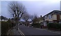
Bournemouth : Boundary Road
Early morning picture of boundary road
Image: © Lewis Clarke
Taken: 6 Jun 2008
0.06 miles
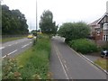
2
Ensbury Park: Boundary Road
This road, unmade till the late 80s, marks the historical boundary between Hampshire and Dorset until 1904, when the area west of here was transferred from Poole to Bournemouth and, therefore, Dorset to Hampshire. Then, in 1974, that area returned to Dorset, along with the rest of Bournemouth. This is now the A347, which used to run up the main shopping street in Winton, Wimborne Road, providing much needed relief for the latter.
Image: © Chris Downer
Taken: 9 Jun 2008
0.06 miles
3
Winton: Boundary Road and bridleway N03 are side by side
The reason for the parallel routes is that the bridleway, also now a service road (right) is the historical course of Boundary Road; the main A347 was built in the 1980s. See Image for more discussion on this, including the fact that the two routes are not quite actually parallel.
See Image for the next view along the route ahead, and Image for the next view behind. These links contain further links to photos all along the course of the bridleway.
Image: © Chris Downer
Taken: 4 Jul 2016
0.06 miles
4
Winton: Boundary Road and bridleway N03 head north
Looking along these two almost parallel routes - they are not quite parallel, though, as they gradually converge. See Image for a view from the other end, about 400m ahead, and more discussion.
Meanwhile, see Image for the next view on the bridleway route ahead, and Image for the next one behind us. Each has links to further photos along the route.
Alongside us, a pedestrian crossing over the main road has been installed in the last 3 or 4 years.
Image: © Chris Downer
Taken: 4 Jul 2016
0.07 miles
5
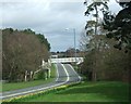
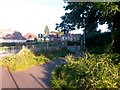
Boundary Road Bridge
This is the southerly of two bridges on Boundary Road, the northerly one is visible in the distance.
Image: © Lorraine and Keith Bowdler
Taken: 5 Apr 2010
0.07 miles
6
Bournemouth : Winton - Glenmoor Road
Glenmoor Road in Winton which leads to Heathwood Road.
Image: © Lewis Clarke
Taken: 8 Dec 2010
0.07 miles
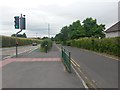
7
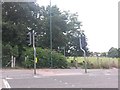
Ensbury Park: footpath N08 reaches Boundary Road
This public footpath, one of Bournemouth's longest at nearly 1200m, reaches its destination on Boundary Road. The route of the right of way is mapped to include the little bend just ahead of us, meeting the pedestrian crossing.
It comes to an end just a couple of yards from the parallel footpath N12.
See Image for the start of the two paths from across the road, and Image for the next view behind us and links to further pictures throughout the length of the route.
Image: © Chris Downer
Taken: 3 Jul 2016
0.07 miles
8
Talbot Village: the start of footpaths N08 and N12
Looking across the main Boundary Road towards the corner of the woods at Talbot Village.
On the right, the paved path N08 is one of Bournemouth's longest public rights of way, running for almost 1200m to Columbia Road. Meanwhile, another footpath, number N12, heads through the gap in the fence, left, and runs parallel with path N08 for the first few hundred yards, but within the woods.
See Image] for the next view along path N08;
Image] for the next view along N12;
each providing links to further photos along the entire routes.
Image: © Chris Downer
Taken: 4 Jul 2016
0.07 miles
9
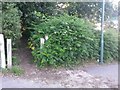
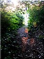
Talbot Village: footpath N12 enters the woods
A closer view of the entrance gateway on Boundary Road - see Image for a wider view, including the start of footpath N08 whose sign we see on the right.
See Image for the view out of the gateway towards us, and links to further pictures along the footpath.
Image: © Chris Downer
Taken: 3 Jul 2016
0.08 miles
10
Talbot Village: footpath N12 arrives at Boundary Road
Looking out of the woods at the end of this public footpath, as it emerges onto the main Boundary Road. The traffic light of a pedestrian crossing is visible.
See Image for the view into the woods from in front of us, and Image for the next view on the path behind us and links to further pictures along the path.
Image: © Chris Downer
Taken: 3 Jul 2016
0.08 miles