IMAGES TAKEN NEAR TO
Balmoral Avenue, BOURNEMOUTH, BH8 9LZ
Introduction
This page details the photographs taken nearby to Balmoral Avenue, BH8 9LZ by members of the Geograph project.
The Geograph project started in 2005 with the aim of publishing, organising and preserving representative images for every square kilometre of Great Britain, Ireland and the Isle of Man.

There are currently over 7.5m images from over14,400 individuals and you can help contribute to the project by visiting https://www.geograph.org.uk
Image Map
Images are licensed for reuse under creativecommons.org/licenses/by-sa/2.0
Notes
- Clicking on the map will re-center to the selected point.
- The higher the marker number, the further away the image location is from the centre of the postcode.
Image Listing (56 Images Found)
Images are licensed for reuse under creativecommons.org/licenses/by-sa/2.0
Image
Details
Distance
1
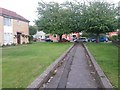
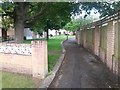
Strouden: footpath K32 approaches Vanguard Road
The opposite view to Image on this public footpath from Craigmoor Avenue. The houses on the left are the highest even numbers of Craigmoor Avenue, even though its dead end is about 150 yards behind us.
A similar path runs alongside the odd numbers and also comes out at the dead end of Craigmoor Avenue: Image
See Image for the next view behind us on this path.
Image: © Chris Downer
Taken: 25 Jun 2016
0.05 miles
2
Strouden: footpath K32 from Vanguard Road
Looking along this footpath which leads to the dead end of Craigmoor Avenue. Although Craigmoor Avenue comes to an end, its houses continue right up to here (those on the right are the highest even numbers). See Image] for the view towards us, and links to further photos along the path.
A similar arrangement exists a few doors along, with another footpath running alongside the odd numbers and coming out on the opposite side of Craigmoor Avenue (see Image).
Image: © Chris Downer
Taken: 25 Jun 2016
0.06 miles
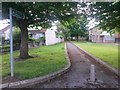
3
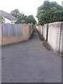
Strouden: footpath K33 from its northern end
A short public footpath, dead straight with uniform but different walls on each side, linking two parallel paths between Vanguard Road and Craigmoor Avenue.
The two paths concerned are:
Image (this end)
Image (far end)
These two images show the meeting point of footpath K33, and links to further images along K31 and K32.
See Image for a view along this path from the far end.
Image: © Chris Downer
Taken: 25 Jun 2016
0.06 miles
4
Strouden: footpath K31 from Vanguard Road
Looking along this footpath which leads to the dead end of Craigmoor Avenue. Although Craigmoor Avenue comes to an end, its houses continue right up to here (those on the left are the highest odd numbers). See Image] for the next view along the path ahead.
A similar arrangement exists a few doors along, with another footpath running alongside the even numbers and coming out on the opposite side of Craigmoor Avenue (see Image).
At the slight kink in the route ahead, a further public footpath links this path with the other: see Image
Image: © Chris Downer
Taken: 25 Jun 2016
0.06 miles
5
Strouden: footpath K32 heads for Vanguard Road
A picture from the same spot as Image but looking in the opposite direction. The houses on the left are even numbers of Craigmoor Avenue, whose dead end is behind us.
A similar path runs alongside the odd numbers: see Image
Opposite the lamppost ahead, a further public footpath links this path with the other: see Image
See Image for the continuing view around the corner ahead.
Image: © Chris Downer
Taken: 25 Jun 2016
0.06 miles
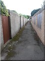
6
Strouden: footpath K33 from its southern end
A short public footpath, dead straight with uniform but different walls on each side, linking two parallel paths between Vanguard Road and Craigmoor Avenue.
The two paths concerned are:
Image (this end)
Image (far end)
These two images show the meeting point of footpath K33, and links to further images along K31 and K32.
See Image for a view along this path from the far end.
Image: © Chris Downer
Taken: 25 Jun 2016
0.06 miles
7
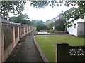
Strouden: footpath K32 heads for Craigmoor Avenue
This public footpath heads from Vanguard Road and reaches Craigmoor Avenue at its dead end, ahead. Although the road stops, its houses continue alongside the path, and these are the even numbers.
A similar situation exists on the opposite side of the road, with another path from Vanguard Road alongside the odd numbers: see Image
See Image for the view towards us from ahead, and Image for the view behind us from here.
Image: © Chris Downer
Taken: 25 Jun 2016
0.07 miles
8
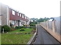
Strouden: footpath K31 passes some houses without a road
This public footpath leads from Vanguard Road (behind us) to the dead end of Craigmoor Avenue (ahead). Although Craigmoor Avenue comes to an end, its houses continue along the path right the way back to Vanguard Road.
See Image for the next view along the path ahead, and Image for a view down it from the Vanguard end.
Image: © Chris Downer
Taken: 25 Jun 2016
0.08 miles
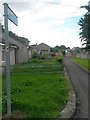
9
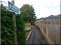
Strouden: footpath K32 is signposted
See Image for a wider view of this end of the path, and further discussion. See Image for a picture towards us from the low wall ahead.
Image: © Chris Downer
Taken: 25 Jun 2016
0.08 miles
10
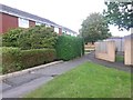
Strouden: entering footpath K32 from Craigmoor Avenue
We stand by the dead end of Craigmoor Avenue, on the even numbered side, and see in front of us a public footpath to Vanguard Road, alongside which the even numbered houses continue even though the road stops here. See Image for the next photo along the path.
A similar arrangement exists on the odds side, with a path almost parallel to this one: Image
Image: © Chris Downer
Taken: 25 Jun 2016
0.09 miles