IMAGES TAKEN NEAR TO
Throop Road, BOURNEMOUTH, BH8 0DH
Introduction
This page details the photographs taken nearby to Throop Road, BH8 0DH by members of the Geograph project.
The Geograph project started in 2005 with the aim of publishing, organising and preserving representative images for every square kilometre of Great Britain, Ireland and the Isle of Man.

There are currently over 7.5m images from over14,400 individuals and you can help contribute to the project by visiting https://www.geograph.org.uk
Image Map
Images are licensed for reuse under creativecommons.org/licenses/by-sa/2.0
Notes
- Clicking on the map will re-center to the selected point.
- The higher the marker number, the further away the image location is from the centre of the postcode.
Image Listing (90 Images Found)
Images are licensed for reuse under creativecommons.org/licenses/by-sa/2.0
Image
Details
Distance
1
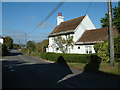
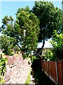
Vine Cottage, Throop
This cottage backs onto the River Stour and gets its name from the vines on the walls.
Image: © Stuart Buchan
Taken: 13 Oct 2005
0.01 miles
2
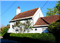
Vine Cottage
Rather a strange name for this beautiful white cottage with a red tile roof on the Troop Road whose front is covered with even more beautiful red roses.
Image: © Nigel Mykura
Taken: 15 Nov 2011
0.02 miles
3
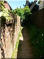
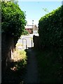
Throop: slightly leaning brick wall alongside footpath K26
Looking eastward along this public footpath towards Throop Road. From the photo it is difficult to tell which wall departs from the vertical, but I think it's the farther one.
See Image for the next view on the path ahead, and Image for the next behind us - each with links to further photos on the route.
Image: © Chris Downer
Taken: 16 Jul 2016
0.03 miles
4
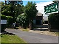
Throop: footpath K26 to Willow Mead
The sign helpfully points us towards the start of this little public footpath, which saves walking along Throop Road and left into Broadway Lane.
See Image for the next view on the path, and links to further photos along the route.
Image: © Chris Downer
Taken: 16 Jul 2016
0.03 miles
5
Throop: footpath K26 emerges onto Throop Road
The eastern end of this public footpath as it comes out of its secluded passageway onto Throop Road.
See Image for the view up the path from ahead, and Image for the next view on the path behind us, with links to further photos along the route.
Image: © Chris Downer
Taken: 16 Jul 2016
0.03 miles
6
Throop: footpath K26 passes some mobile homes
Looking eastward along this public footpath as it passes the back of the Roi-Mar Mobile Homes Park.
See Image for the next view on the path ahead, and Image for the next behind us - each with links to further photos on the route.
Image: © Chris Downer
Taken: 16 Jul 2016
0.03 miles
7
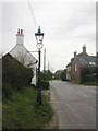
Throop, gas lamp no. 2
One of 28 gas lamps in Throop & Holdenhurst listed by English Heritage http://www.imagesofengland.org.uk/Details/Default.aspx?id=352106&mode=adv; relocated from elsewhere in Bournemouth. This pattern (with bulbous stem bottom & protruding bosses) is still common in older suburbs, though converted to electricity. Perhaps installed here to enhance the area's picturesque nature.
Image: © Mike Faherty
Taken: 26 Feb 2009
0.03 miles
8
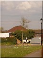
Throop: daffodils under tree
A horse rider travels along Throop Road past the Stour Walk turning, where a young tree has daffodils at its feet. To the right is one of the fake-old lampposts which were installed when this development was built around 10 years ago.
Image: © Chris Downer
Taken: 5 Apr 2009
0.03 miles
9
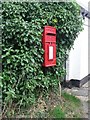
Throop: postbox № BH8 274, Throop Road
An Elizabeth II-reign postbox mounted on a post, half hidden in a hedge in Throop village.
Image: © Chris Downer
Taken: 18 Jul 2008
0.04 miles
10
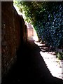
Throop: the shadow of a wall on footpath K26
Looking westward along this public footpath towards Willow Mead. The time of day means that we have a narrow shaft of light along the course of the path, between the shadow of the left-hand wall and under cover of the overhanging hedge on the right.
See Image for the next view on the path ahead, and Image for the next behind us - each with links to further photos on the route.
Image: © Chris Downer
Taken: 16 Jul 2016
0.05 miles