IMAGES TAKEN NEAR TO
Iford Lane, BOURNEMOUTH, BH6 5QY
Introduction
This page details the photographs taken nearby to Iford Lane, BH6 5QY by members of the Geograph project.
The Geograph project started in 2005 with the aim of publishing, organising and preserving representative images for every square kilometre of Great Britain, Ireland and the Isle of Man.

There are currently over 7.5m images from over14,400 individuals and you can help contribute to the project by visiting https://www.geograph.org.uk
Image Map
Images are licensed for reuse under creativecommons.org/licenses/by-sa/2.0
Notes
- Clicking on the map will re-center to the selected point.
- The higher the marker number, the further away the image location is from the centre of the postcode.
Image Listing (60 Images Found)
Images are licensed for reuse under creativecommons.org/licenses/by-sa/2.0
Image
Details
Distance
1
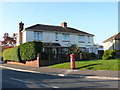
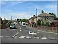
Houses on Iford Lane
These semi-detached houses are at the junction with Collingbourne Lane. The houses have a small green in front of them and are recessed from Iford Lane.
Image: © Nigel Mykura
Taken: 15 Nov 2011
0.02 miles
2
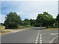
Iford Lane, Iford, near Bournemouth
Iford Lane is a suburban road through Iford, on the north-eastern fringe of Bournemouth.
Image: © Malc McDonald
Taken: 21 Jun 2022
0.03 miles
3
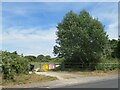
Queen Elizabeth II Field, Iford, near Bournemouth
An entrance to the Queen Elizabeth II Field in Iford, on the outskirts of Bournemouth.
Image: © Malc McDonald
Taken: 21 Jun 2022
0.03 miles
4
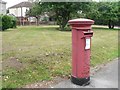
Iford: postbox № BH6 364, Collingbourne Avenue
The eastern junction of Collingbourne Avenue has a large central island, and the houses are set back behind a semicircular grassed area, which we see here behind the box.
Image: © Chris Downer
Taken: 19 Jul 2008
0.05 miles
5
Dickens Road, Iford, near Bournemouth
Dickens Road is a minor residential road in Iford, on the north-eastern outskirts of Bournemouth.
Image: © Malc McDonald
Taken: 21 Jun 2022
0.05 miles
6
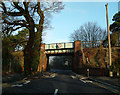
Iford Lane Railway Bridge
The main London to Weymouth railway crosses Iford Lane by this plate girder bridge.
Image: © Peter Kazmierczak
Taken: 20 Feb 2011
0.06 miles
7
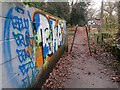
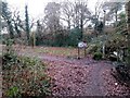
Tuckton: graffiti on footpath I23
This public footpath comes up from Iford Lane (behind us) into The Rookery, a wooded public space. The course of the public right of way turns left immediately beyond the wall, bound for Northey Road. The path ahead, though not designated a right of way, is also available and leads to Beaufort Road.
Graffiti adorns not only the wall on the left, but also the sign welcoming us to The Rookery, to the right just beyond the telegraph pole.
See Image for the next view on the path behind us, and Image for the next view ahead, with links to further photos along the public footpath.
Image: © Chris Downer
Taken: 8 Jan 2017
0.07 miles
8
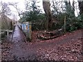
Tuckton: a corner is turned on footpath I23
This public footpath comes up from Iford Lane (ahead) into The Rookery, this wooded public space. The course of the public right of way heads to the right just here, bound for Northey Road, while the path behind us towards Beaufort Road is not designated a public right of way.
See Image for the next view on the path ahead, and Image for the next view on the path to the right - each with links to further photos along the public footpath.
Image: © Chris Downer
Taken: 8 Jan 2017
0.07 miles
9
Tuckton: footpath I23 approaches the railway embankment
This public footpath from Northey Road comes through the edge of The Rookery, a wooded open space, and turns right just ahead to arrive on Iford Lane. The main railway line is just ahead.
See Image for the next view on the path ahead, and Image for the next view behind - each with links to further photos along the public footpath.
Image: © Chris Downer
Taken: 8 Jan 2017
0.07 miles
10
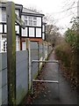
Tuckton: footpath I23 from Iford Lane
This public footpath leads between 154 Iford Lane and the railway embankment, to Northey Road via The Rookery (signposted), a wooded enclave within this part of suburbia.
See Image for the next photo along the path, with links to further pictures along the route.
Image: © Chris Downer
Taken: 8 Jan 2017
0.08 miles